Warby Range Estate - Glenrowan IN PLANNING
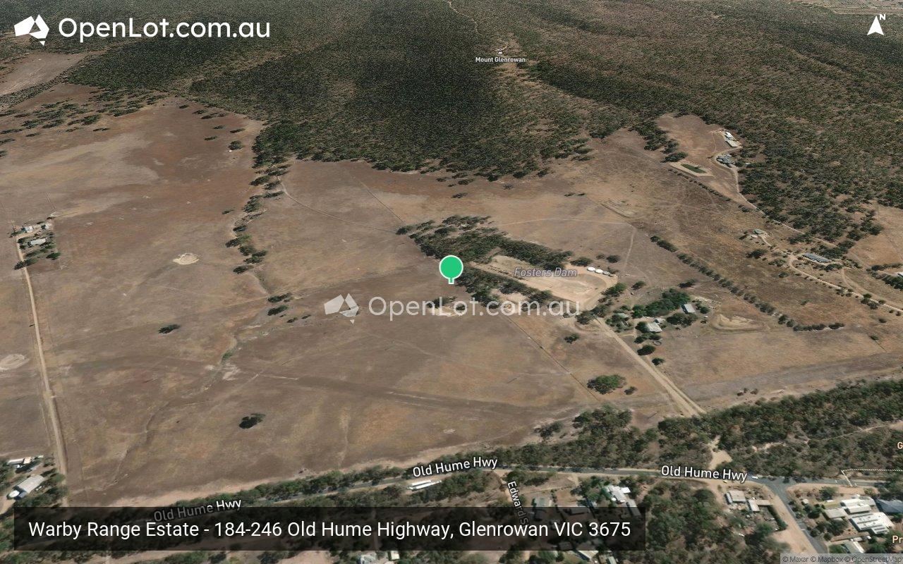
 184-246 Old Hume Highway, Glenrowan VIC 3675
This information is estimated by the OpenLot research team. Let us know here to provide up-to-date information about this development.
| Total new homes | N/A |
| Area size | 102.63 hectares |
| City council | Rural City Of Wangaratta |
| Developer | N/A |
Land for Sale, House and Land Packages:
Popular Estates near Warby Range Estate - Glenrowan


 3
3  2
2  2
2


Updates for Warby Range Estate - Glenrowan
Facebook updates:
Submit the Facebook page for Warby Range Estate - Glenrowan.
Related news:
Rural & Farming for Sale at 184 Old Hume Highway, Glenrowan VIC 3675. ENJOY FARM LIFE IN TOWN. See if it's right for you or find something similar at Commercial Real Estate.


Missing articles? Send us a link here.
Location & Map for Warby Range Estate - Glenrowan
Land Price Trend in Glenrowan VIC 3675
- In Jul - Sep 21, the median price for vacant land in Glenrowan VIC 3675 was $179,500. *
- From Jan - Mar 21 to Jul - Sep 21, the median price for vacant land in Glenrowan VIC 3675 has increased 12.19%. *
- From 2021 to 2021, the median price for vacant land in Glenrowan VIC 3675 has increased 0%. *
Vacancy Rate in Glenrowan VIC 3675
View full vacancy rate history in Glenrowan VIC 3675 via SQM Research.
Schools near Warby Range Estate - Glenrowan
Here are 6 schools near Warby Range Estate - Glenrowan:
Prep-6 Government Primary School
Prep-6 Government Primary School
Prep-6 Government Primary School
Prep-6 Catholic Primary School
Prep-6 Government Primary School
Prep-5 Government Primary School
Reviews & Comments on Warby Range Estate - Glenrowan
Estate Brochure, Masterplan, Engineering Plan, Plan of Subdivision (POS), Design Guidelines
FAQs about Warby Range Estate - Glenrowan
- Glenrowan Primary School - 545m south-east
- Oxley Primary School - 12.8km east
- Yarrunga Primary School - 12.9km north-east
- Our Lady's School - 13.1km north-east
- Wangaratta West Primary School - 13.8km north-east
- Winton Primary School - 13.9km south-west
Popular Estates near Warby Range Estate - Glenrowan
Latest New Home Articles for You

05/Mar/2025 | OpenLot.com.au
Display Homes at Alfredton Grove Estate: A Premier Community in Alfredton's Growing West
Alfredton Grove has become one of the most desirable residential communit...

04/Mar/2025 | OpenLot.com.au
Display Homes at Ooranya: Beveredige's Perfect Blend of Country Living and Modern Convenience
Nestled in the charming town of Beveridge, Ooranya is a community designe...

03/Mar/2025 | OpenLot.com.au
The Rise of Regional Living: Why More Australians are Moving Beyond Major Cities
In recent years, Australia has witnessed a significant shift in populatio...
28/Feb/2025 | OpenLot.com.au
2025 Property Investment Strategies: How to Maximise ROI
As Australia’s real estate market evolves, property investors are seeking...

27/Feb/2025 | OpenLot.com.au
Display Homes at Everley: The Heart of Sunbury’s Newest Community
Everley proudly stands at the centre of Sunbury, offering an unparalleled...

25/Feb/2025 | OpenLot.com.au
Western Australia’s Most Popular Land Estates for January 2025: Top Picks Across Growth Areas
Western Australia’s property market continues to show robust growth, with...

24/Feb/2025 | OpenLot.com.au
South Australia’s Most Popular Land Estates for January 2025: Top Picks Across Growth Areas
South Australia’s property market is gaining momentum, with growth areas ...

23/Feb/2025 | OpenLot.com.au
Exploring the Impact of Technology on Home Buying: A Comprehensive Overview
The latest episode of the "Home Building Hub" podcast delved into this to...

22/Feb/2025 | OpenLot.com.au
Display Homes at Cloverton: Kalkallo Perfect Balance of City and Nature
If you're seeking a harmonious balance between vibrant city life and sere...