
Stonefields Estate - Wollert SOLD OUT
 260 Craigieburn Road, Wollert VIC 3750
[LIMITED OFFER] Stages 1 to 4 sold out, Stage 5 Coming Soon - Register Now
- Conveniently situated between Craigieburn and Epping, with public transport available within minutes of Stonefields
- 7 hectares of proposed active open space incorporating 3 soccer fields, bicycle and walking paths and 3.55 hectares of public open space and reserves.
- A short drive to access everything available in Epping’s town centre and also minutes from Craigieburn town centre and public services.
- Great private and public primary and secondary schools and child care centres nearby
This information is estimated by the OpenLot research team. Let us know here to provide up-to-date information about this development.
| Total new homes | N/A |
| Area size | 41.84 hectares |
| Growth Region | Melbourne North Growth Corridor |
| City council | Whittlesea City Council |
| Developer | N/A |
| Project marketer | GBL Property Consultants |
| Creative agency | Easy Digital Marketing |
| Distance to | Melbourne Airport - 16 km north-east Melbourne CBD - 24 km north |
Land for Sale:
Popular Estates near Stonefields Estate - Wollert


 4
4  2
2  2
2


Updates for Stonefields Estate - Wollert
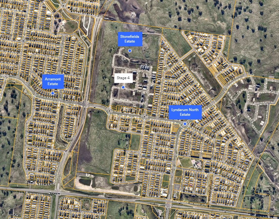
Location & Map for Stonefields Estate - Wollert
Visit Display Homes near Stonefields Estate - Wollert


Land Price Trend in Wollert VIC 3750
- In Apr - Jun 24, the median price for vacant land in Wollert VIC 3750 was $380,000. *
- From Oct - Dec 17 to Apr - Jun 24, the median price for vacant land in Wollert VIC 3750 has increased 33.33%. *
- From 2009 to 2023, the median price for vacant land in Wollert VIC 3750 has increased 102.25%. *
Vacancy Rate in Wollert VIC 3750
View full vacancy rate history in Wollert VIC 3750 via SQM Research.
Schools near Stonefields Estate - Wollert
Here are 6 schools near Stonefields Estate - Wollert:
Prep-6 Government Primary School
Prep-6 Government Primary School
7-12 Government Secondary School
Prep-6 Government Primary School
7 Government Secondary School
Prep-6 Government Primary School
Reviews & Comments on Stonefields Estate - Wollert
Estate Brochure, Masterplan, Engineering Plan, Plan of Subdivision (POS), Design Guidelines
FAQs about Stonefields Estate - Wollert
View all estates marketed by GBL Property Consultants
- Barrawang Primary School - 791m west
- Edgars Creek Primary School - 961m south
- Edgars Creek Secondary College - 1.7km south
- Harvest Home Primary School - 2.2km south
- Wollert Secondary College - 2.3km south-east
- Wollert Primary School - 2.6km south-east
Popular Estates near Stonefields Estate - Wollert
Latest New Home Articles for You

03/Mar/2025 | OpenLot.com.au
The Rise of Regional Living: Why More Australians are Moving Beyond Major Cities
In recent years, Australia has witnessed a significant shift in populatio...
28/Feb/2025 | OpenLot.com.au
2025 Property Investment Strategies: How to Maximise ROI
As Australia’s real estate market evolves, property investors are seeking...

27/Feb/2025 | OpenLot.com.au
Display Homes at Everley: The Heart of Sunbury’s Newest Community
Everley proudly stands at the centre of Sunbury, offering an unparalleled...

25/Feb/2025 | OpenLot.com.au
Western Australia’s Most Popular Land Estates for January 2025: Top Picks Across Growth Areas
Western Australia’s property market continues to show robust growth, with...

24/Feb/2025 | OpenLot.com.au
South Australia’s Most Popular Land Estates for January 2025: Top Picks Across Growth Areas
South Australia’s property market is gaining momentum, with growth areas ...

23/Feb/2025 | OpenLot.com.au
Exploring the Impact of Technology on Home Buying: A Comprehensive Overview
The latest episode of the "Home Building Hub" podcast delved into this to...

22/Feb/2025 | OpenLot.com.au
Display Homes at Cloverton: Kalkallo Perfect Balance of City and Nature
If you're seeking a harmonious balance between vibrant city life and sere...

21/Feb/2025 | OpenLot.com.au
Queensland’s Most Popular Land Estates for January 2025: Top Picks Across Growth Areas
Queensland’s property market continues to attract homebuyers and investor...

19/Feb/2025 | OpenLot.com.au
New South Wales’ Most Popular Land Estates for January 2025: Top Picks Across Growth Areas
As New South Wales’ property market continues to thrive, several housing ...