The Parks at Stoneleigh Estate - Logan Reserve SOLD OUT
This information is estimated by the OpenLot research team. Let us know here to provide up-to-date information about this development.
| Total new homes | 30 |
| Area size | N/A |
| Growth Region | Greater Brisbane Growth Areas |
| City council | Logan City Council |
| Developer | Urbane Homes |
| Project marketer | Elders Project Marketing - Brisbane |
| Distance to | Brisbane CBD - 28 km south Brisbane Airport - 35 km south Gold Coast CBD - 44 km north-west |
House and Land Packages:
Popular Estates near The Parks at Stoneleigh Estate - Logan Reserve
Updates for The Parks at Stoneleigh Estate - Logan Reserve
Location & Map for The Parks at Stoneleigh Estate - Logan Reserve
Display Homes near The Parks at Stoneleigh Estate - Logan Reserve
Vacancy Rate in Logan Reserve QLD 4133
View full vacancy rate history in Logan Reserve QLD 4133 via SQM Research.
Schools near The Parks at Stoneleigh Estate - Logan Reserve
Here are 6 schools near The Parks at Stoneleigh Estate - Logan Reserve:
Prep-6 Government Primary School
Prep-12 Independent Combined School
7-12 Government Secondary School
Prep-6 Government Primary School
Prep-6 Government Primary School
Prep-12 Catholic Combined School
Suburb Planning Review in Logan Reserve QLD 4133
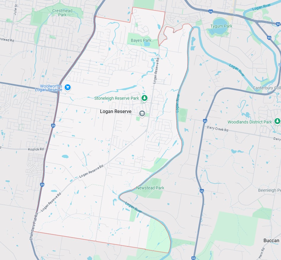
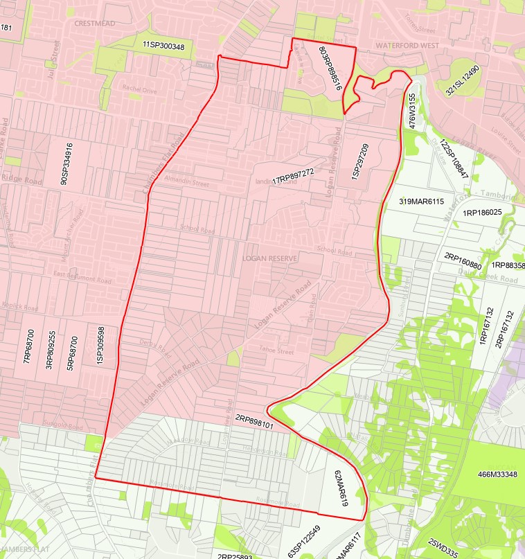
Logan Reserve is approximately 14.6 square kilometres within the City of Logan, forming part of the southern urban area of the greater Brisbane metropolitan region within South East Queensland, located 10 kilometres south of Logan Central and 35.3 South of Brisbane CBD.
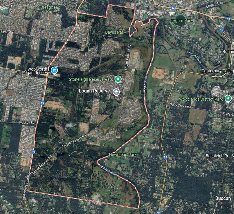
The suburb boundary is located along the Logan River and Logan Reserve Road to the east. Beutel Street, Lakeview Drive and property boundaries make up the northern boundary. The Chambers Flat Road make up the western boundary and Rossmore Road make up the southern boundary.
Loganview Road and Logan Reserve Road provide local road access (north to south) and connect the local road network found throughout Logan Reserve. Bays Road and School Road provide the east-west connections through the area and access to Chambers Flat Road area.
The suburb of Logan Reserve provides a mix of land uses, with the northern portion developed with new urban residential development and new Woolworths supermarket. The suburb contains mostly Rural living properties, and the vegetated waterway corridor is located throughout the suburb.
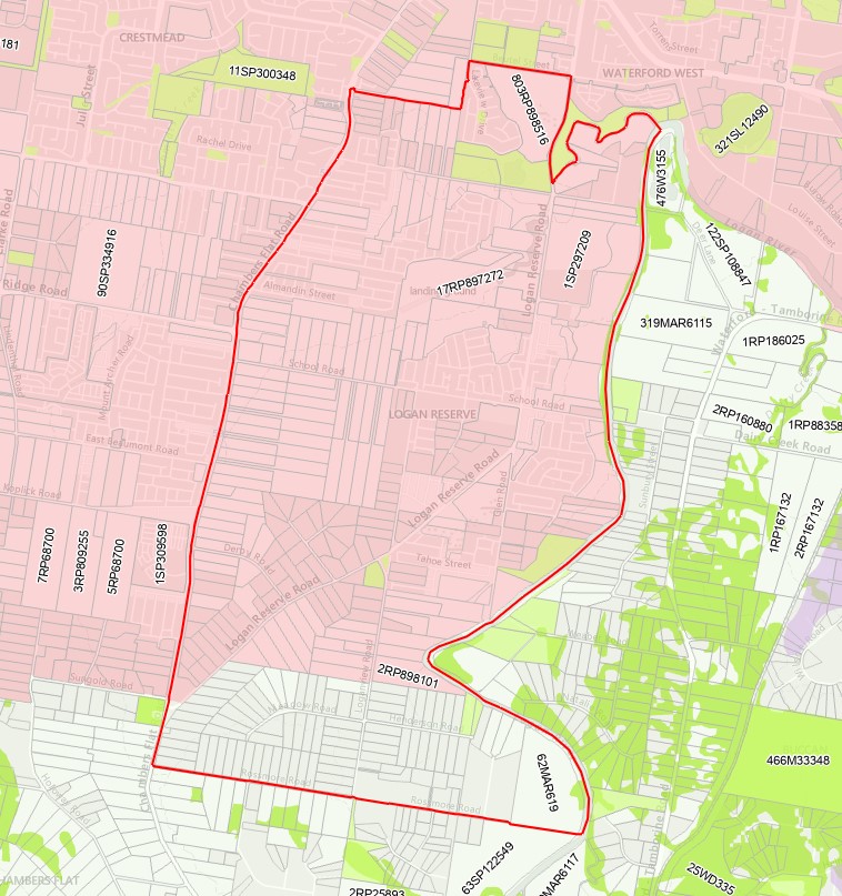
Pockets of urban development are located around the creek corridors traversing the suburb, which includes established urban areas and land with potential for new urban development. The area incorporates scattered industry uses, home businesses, poultry and rural living in a large portion of the suburb. The new denser developments have community facilities and other integral components of well-planned urban environments, such as local areas for sport and recreation and urban open space. The council planning scheme includes zoning to allow land uses to align with the purpose of the urban footprint in accordance with the SEQ Regional Plan.
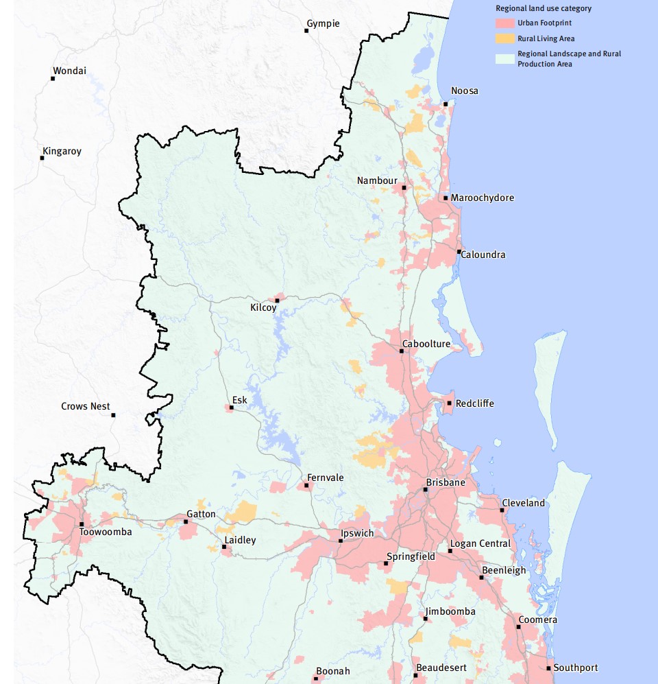
SEQ Regional Plan 2009–2031
The South East Queensland Regional Plan 2017, also known as ShapingSEQ is a regional plan for South East Queensland (SEQ), Australia. It is a long-term strategic plan that guides land use and development in the region. Developed by the Queensland Government, ShapingSEQ is intended to support sustainable growth and development while protecting the region's natural and cultural heritage. The plan includes policies and guidelines on land use, infrastructure, transport, environment, and economic development.
The plan identifies priority growth areas and development corridors, and sets targets for population growth and housing supply in the region. It also includes strategies for managing urban sprawl, protecting natural resources and biodiversity, and addressing climate change impacts.
The plan also lays out the vision for the region in 2041 which includes a liveable, sustainable, and prosperous region, with a focus on protecting the environment and encouraging sustainable development, as well as improving connectivity and accessibility throughout the region. ShapingSEQ provides a regional framework for growth management and sets the planning direction for sustainable growth, global economic competitiveness, and high-quality living by:
- identifying a long-term sustainable pattern of development which focuses more on growth in existing urban areas
- harnessing regional economic strengths and clusters to compete globally
- ensuring land use and infrastructure planning are integrated
- valuing and protecting the natural environment, productive land, resources, landscapes, and cultural heritage
- promoting more choice of housing and lifestyle options
- locating people and jobs closer together, and moving people and goods more efficiently and reliably
- promoting vibrant, fair, healthy, and affordable living and housing to meet all the community's needs
- valuing design and embracing the climate to create high-quality living environments
- maximising the use of existing infrastructure and planning for smarter solutions for new infrastructure
- supporting strong rural communities and economic diversification.
South East Queensland City Deal – Implementation Plan
The Australian Government, Queensland Government, and Council of Mayors (SEQ) are already delivering for local communities throughout South East Queensland. They are focused on commitments that meet four strategic outcomes: accelerating future jobs across SEQ; a faster, more connected SEQ region; a more liveable SEQ; and creating thriving communities for SEQ.
The SEQ City Deal agreement was signed on 21 March 2022 by the Australian Government, Queensland Government and Council of Mayors (SEQ). The accompanying Deal document sets out the vision, objectives, and commitments.
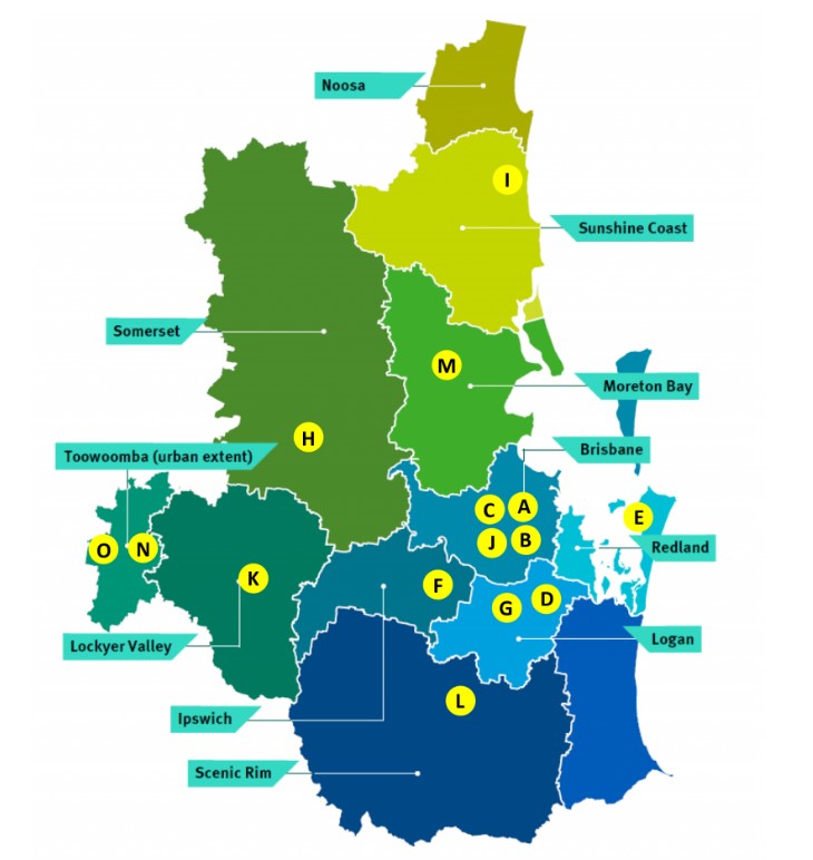
The SEQ City Deal Implementation Plan was released in July 2023 and provides details about how the Deal will be delivered, commitment milestones and funding arrangements. The document identifies the Local City Council area as G (Strategic Corridor Planning).
The Logan Plan 2025
Logan is set to become one of South East Queensland’s fastest-growing regions, with its population projected to surpass 500,000 by 2036. To manage this rapid growth, Logan City Council has introduced the Logan Plan—a forward-thinking strategy to ensure sustainable development, infrastructure delivery, and the preservation of the city’s natural and cultural treasures. This new planning scheme integrates innovative approaches to flood risk, housing, and job creation, while supporting emerging suburbs.
Key Objectives:
- Growth Management: Support housing choice and job opportunities across Logan’s established and emerging suburbs.
- Infrastructure Delivery: Guide development of roads, parks, water, and community facilities.
- Flood Risk Mitigation: Introduce stronger safety measures in flood-prone areas, incorporating climate change risks.
- Environmental Protection: Safeguard green spaces, waterways, and wildlife.
- Design and Heritage: Promote sustainable urban design, safety, and heritage preservation.
New Features & Decisions:
- Council Commitment (July 2021): Logan City Council committed to a new planning scheme to address flood risks, introduce updated design guidelines, and plan for sustainable growth in emerging suburbs. These areas include regions outside the Flagstone and Yarrabilba priority development areas, which will remain under the state government’s Economic Development Act 2012.
- Integrated Strategies: The Logan Plan integrates the findings of the Logan Housing Study and the Logan Employment Lands Strategy, ensuring the city’s planning scheme meets the housing and job needs of a growing population.
Timeframe & Process (2024 and Beyond):
- 2024: Align the draft Logan Plan with the updated ShapingSEQ 2023 regional plan under Queensland Government direction.
- 2025: Begin formal community consultation to gather feedback and refine the plan.
- 2026+: Conduct a second review by the Queensland Government before final approval and implementation.
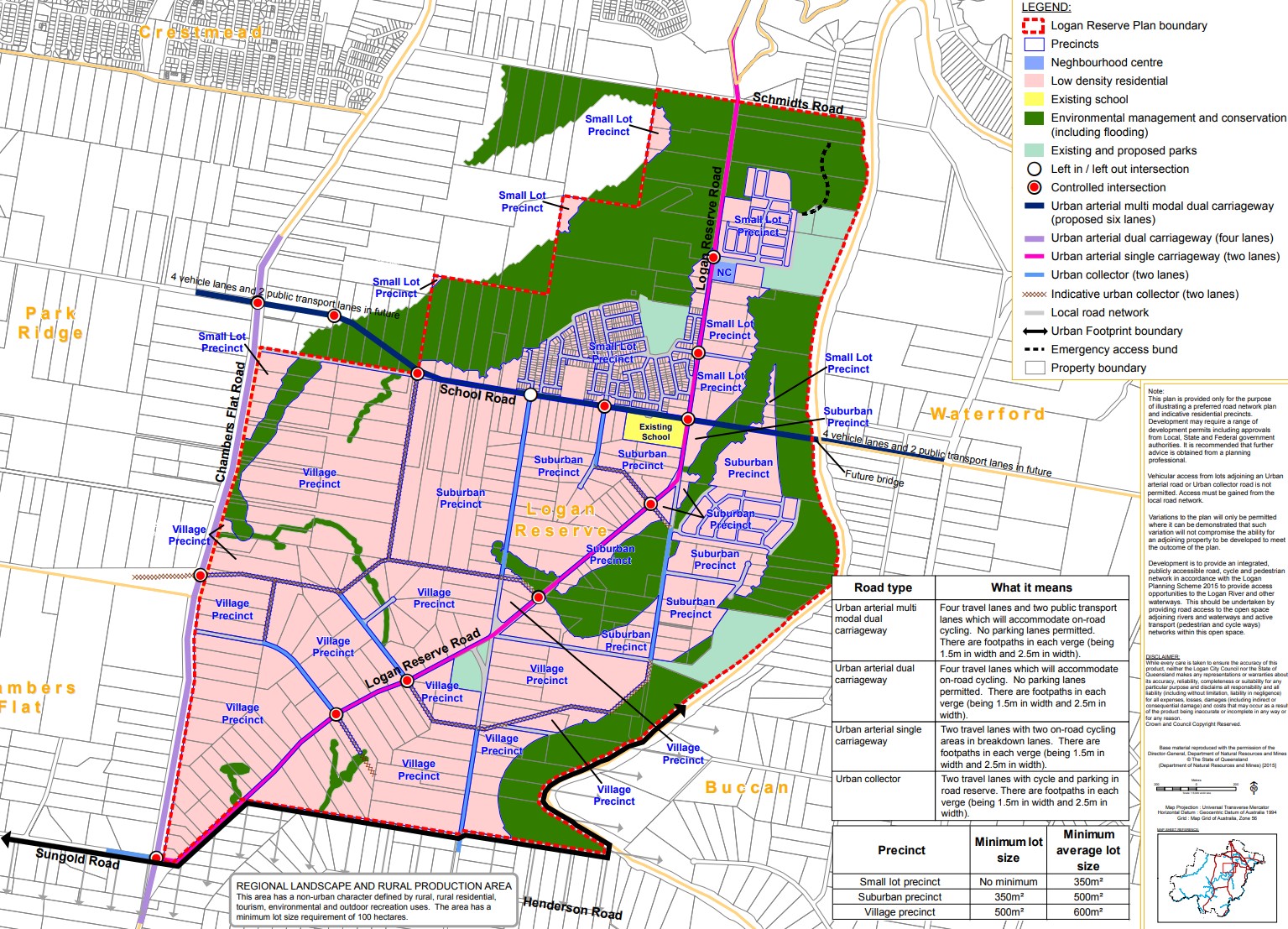
Logan Reserve Plan 2018
In 2009, the Queensland State Government identified part of Logan Reserve for future urban development, prompting Logan City Council to develop a detailed plan addressing land use, infrastructure, environmental factors, and flooding constraints. The draft plan, created in 2017, underwent public consultation between April and June of that year. Based on community feedback, revisions were made, and the plan was endorsed by Council on 29 August 2017.
Further community input was sought in 2018 before incorporating the Logan Reserve Plan into the Logan Planning Scheme 2015. The process emphasized collaboration, ensuring the plan aligned with both community needs and state requirements. The plan focused on the township zoning and didn’t address the whole suburb.
Logan Planning Scheme 2015 (currently implemented)
The Planning Act 2016 provides Queensland’s legislative framework for land use planning and development assessment across state, regional, and local levels. In the City of Logan, the Logan Planning Scheme 2015 serves as the local planning instrument that governs these matters.
Since its introduction, the Logan Planning Scheme has undergone multiple amendments as part of a continuous improvement program. These updates ensure the scheme remains relevant and effective in meeting the needs of Logan’s growing population.
Suburb Summary
References
South East Queensland City Deal – Implementation Plan
Draft Logan Plan 2025
Reviews & Comments on The Parks at Stoneleigh Estate - Logan Reserve
Estate Brochure, Masterplan, Engineering Plan, Plan of Subdivision (POS), Design Guidelines
FAQs about The Parks at Stoneleigh Estate - Logan Reserve
View all estates from Urbane Homes
View all estates marketed by Elders Project Marketing - Brisbane
- Logan Reserve State School - 794m east
- St Philomena School - 2.3km west
- Marsden State High School - 3.0km north
- Crestmead State School - 3.0km north-west
- Marsden State School - 3.1km north
- St Francis College - 3.3km north-west
Popular Estates near The Parks at Stoneleigh Estate - Logan Reserve
Latest New Home Articles for You

13/Dec/2024
The Aussie Dream Is Alive: Despite Worry That New Homebuyers Must Settle for Apartments, New Data Reveals Australians Buy Twice as Many New Houses as Units
MELBOURNE (15 October 2024) — The Australian Dream of owning a detached h...

10/Dec/2024
Data Reveals It Costs 57% More to Build a New House than Before Covid
MELBOURNE (10 September 2024) — Australians are spending as much as 57% m...

21/Nov/2024
Decoding Terms Found In Drawings & Plans
In the latest episode of "The Home Building Hub" podcast, hosts Colin Bis...

12/Nov/2024
Victoria: Top 30 Most Searched Housing Developments (October 2024)
We’re excited to present the top 30 most popular housing developments in ...

12/Nov/2024
Western Australia: Top 30 Most Searched Housing Developments (October 2024)
If you've ever envisioned calling Western Australia home, now is an excel...

12/Nov/2024
South Australia: Top 30 Most Searched Housing Developments (October 2024)
South Australia, celebrated for its breathtaking landscapes and vibrant c...

12/Nov/2024
New South Wales: Top 30 Most Searched Housing Developments (October 2024)
If you've considered making New South Wales your home, now is an ideal ti...

12/Nov/2024
Queensland: Top 30 Most Searched Housing Developments (October 2024)
Spanning the sunlit shores of Australia’s eastern coast, Queensland—affec...
![[Oct/2024] Top Most Searched Housing Developments in Australia](https://files.openlot.com.au/p/styles/500h/s3/article/Thumbnail%20-%20Top%2030%20Most%20Searched%20Housing%20Developments_0.png.webp?itok=YtDmCKiT)
06/Nov/2024
[Oct/2024] Top Most Searched Housing Developments in Australia
OpenLot offers an in-depth look at top housing developments making an imp...


 Chikameena Street, Logan Reserve QLD 4133


