Jindowie Estate - Yanchep
- Next door to Yanchep Central Shopping Centre
- Joondalup Shopping Centre 24 minutes’ drive
- 3 minutes to the beach
- Joondalup Hospital 27 minutes
- Easy access to Mitchell Freeway and Wanneroo Road
- Yanchep Secondary College and child care centre located within the estate
- Future Yanchep Train Station minutes away
- Easy access to Mitchell Freeway, Wanneroo Road and Marmion Avenue
- Yanchep Medical Centre located on Village Row
- Fencing and front landscaping included as standard
- Close to Yanchep National Park
This information is estimated by the OpenLot research team. Let us know here to provide up-to-date information about this development.
| Total new homes | 1,402 |
| Area size | N/A |
| Growth Region | Perth North West Growth Areas |
| City council | City of Wanneroo |
| Developer | DevelopmentWA |
| Distance to | Perth CBD - 49 km north-west |
Land for Sale, House and Land Packages:
Popular Estates near Jindowie Estate - Yanchep
Updates for Jindowie Estate - Yanchep
Location & Map for Jindowie Estate - Yanchep
Display Homes near Jindowie Estate - Yanchep
Schools near Jindowie Estate - Yanchep
Here are 6 schools near Jindowie Estate - Yanchep:
7-12 Government Secondary School
K-6 Government Primary School
K-6 Government Primary School
K-6 Government Primary School
Unknown Government School
K-6 Government Primary School
Suburb Planning Review in Yanchep WA 6035
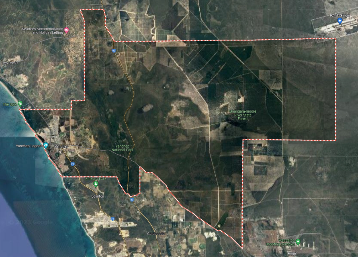
Yanchep is made up of a large area, approximately 220 square kilometres and takes up almost the entire northern and north-eastern portion of the City of Wanneroo. The suburb forms part of the northern coastal region of Perth that is located 56 kilometres south.
Yanchep National Park and Gnangara-Moore River State Forest occupy the middle and most eastern portion of the suburb, with the township of Yanchep located to the west towards the ocean. The coastal township contains a northern urbanised area, local centres (commercial and retail), large residential areas, parks and schools. For the most part, the suburb is covered in native banksia woodland, scrubland and heath typical of the Swan Coastal Plain.
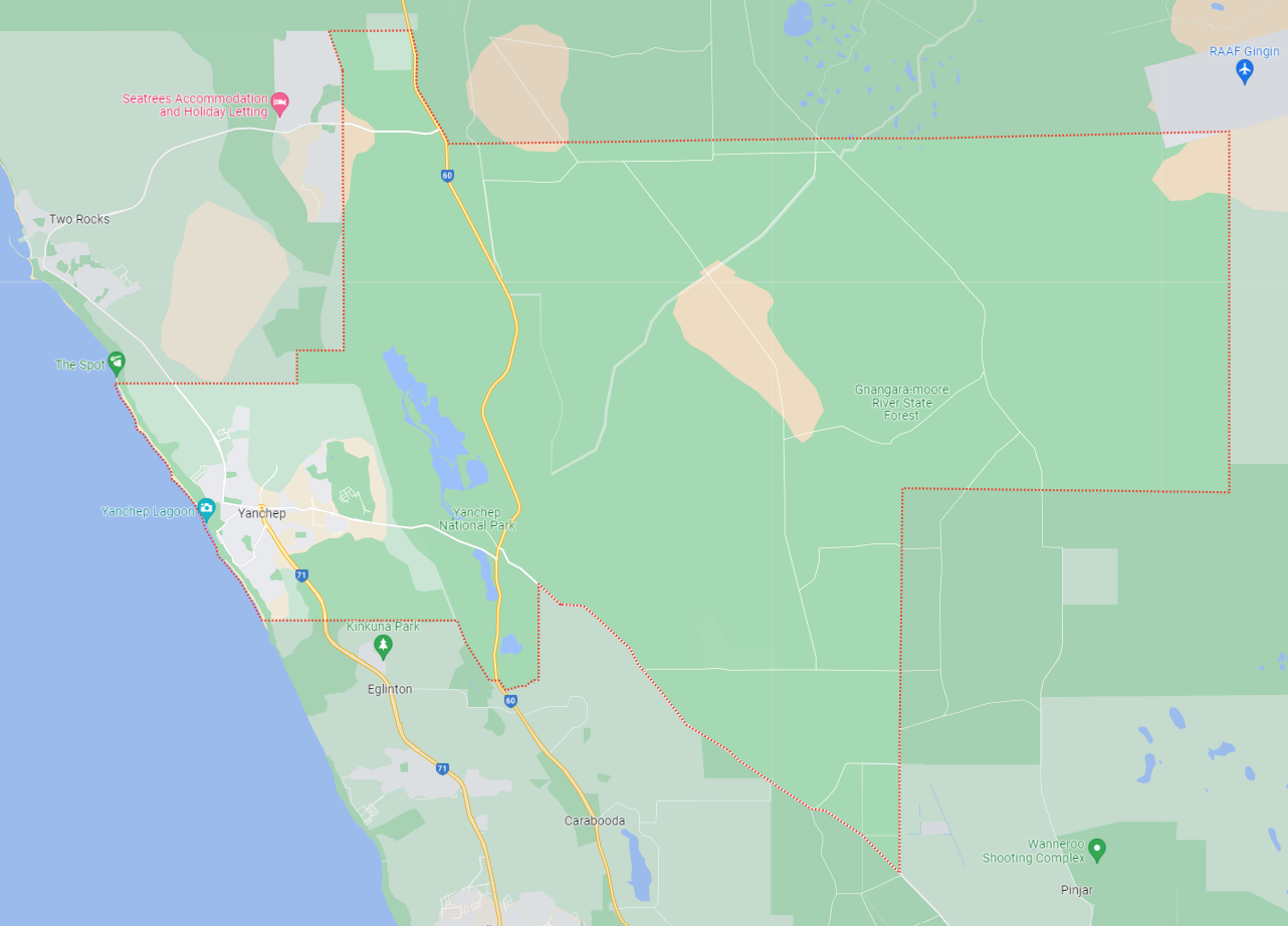
The suburb boundary is located along property boundaries to the south. The RAAF Gingin Airport, Yeal National Park, Old Pine Plantation and property boundaries contribute to the entire northern boundary, property boundaries to the East and the Pinjar Power Station further east. The Indian Ocean and property boundaries provide the suburb boundary to the west.
A local road network is found throughout Yanchep, providing access to the surrounding suburbs and the local network of roads. Yanchep Beach Road and Pigeon Road provide west and east connections through the centre of the suburb, whilst Indian Ocean Drive, Aqua Drive, Water Road and Marmion Avenue provide north and south connections linking to the major arterial road in proximity.
The suburb is large and contains the last northern urban area of Perth. Positioned along the coastline, Yanchep is known for its beaches, natural beauty, and Yanchep National Park. The town features residential areas, commercial and retail centres, parks and recreational areas, schools, and health services. The town has a mix of housing types, including houses, apartments, and townhouses.
Yanchep is a part of the City of Wanneroo local government area. Originally a small crayfishing settlement, it was developed by entrepreneur Alan Bond in the 1970s for the 1977 America's Cup
Yanchep has experienced significant growth in recent years, with many new residential developments and infrastructure projects underway. The suburb's population is expected to continue to increase. The suburb currently has a number of schools, including Yanchep Beach Primary School, Yanchep Secondary College, St James' Anglican School, Yanchep Lagoon Primary School and Northshore Christian Grammar School.
Yanchep is a rapidly growing suburb located in the northern coastal region of Perth, Western Australia. The Western Australian government has identified Yanchep as a key growth area, with plans to develop a range of amenities and infrastructure to support the growing population. These plans include the extension of the Mitchell Freeway and the construction of a new railway station at Yanchep, which will provide faster and more efficient transport links to Perth and other parts of the region.
In addition to new infrastructure projects, there are also several new residential developments underway in Yanchep, including the Capricorn Beach estate, which will provide more than 3,500 new homes and a range of community facilities.
Northern Coastal Growth Corridor
The City of Wanneroo identifies Yanchep within its Northern Coastal Growth Corridor Community Facilities Plan Review 2019-2029, dated 10 January 2020. This planning document provides a framework for the provision of community facilities in the northern coastal suburbs of Perth, and identifies the community's current and future needs and outlines strategies to provide the necessary facilities and services.
The Northern Coastal Growth Corridor Community Facilities Plan Review 2019-2029 is one of several plans that contribute to the implementation of the Wanneroo North-West District Structure Plan. It provides a detailed focus on the provision of community facilities and services in the northern coastal suburbs, including Yanchep. Together, these plans help to guide the sustainable and coordinated development of the area including three significant growth area opportunities.
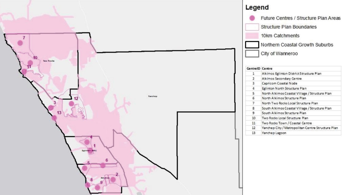
The Northern Coastal Growth Corridor Community Facilities Plan Review 2019-2029 outlines a range of strategies and actions to support the growth and development of the Yanchep area, as well as other areas along the Northern Coastal Growth Corridor in Western Australia.
Some of the key structure plans identified in the review include:
- Yanchep District Open Space Strategy: This plan aims to identify and prioritize the development of open space and recreational facilities in the Yanchep area. This includes the provision of parks, sporting fields, and other outdoor spaces to support the health and wellbeing of the local community.
- Yanchep District Centre Structure Plan: This plan outlines the proposed development of the Yanchep District Centre, which is intended to be a major commercial and civic hub for the area. The plan includes provisions for retail and commercial space, community facilities, and public transport connections.
- Yanchep-Two Rocks Local Area Plan: This plan sets out a vision for the Yanchep-Two Rocks area over the next 20 years, including provisions for residential, commercial, and industrial development, as well as the protection of natural and cultural heritage sites.
- Yanchep Rail Extension Project: As mentioned earlier, this project aims to extend the Perth metropolitan rail network north to Yanchep, providing improved access to employment, education, and other services for local residents.
These plans and projects are designed to support the growth and development of the Yanchep area, while ensuring that the needs of the local community are met in terms of access to services, facilities, and open spaces. The review emphasizes the importance of community engagement and consultation in the development of these plans, to ensure that they reflect the needs and aspirations of the local community.
Yanchep District Open Space Strategy
The Yanchep District Open Space Strategy is a plan to develop open spaces and recreational facilities in the Yanchep area of Western Australia, in response to population growth and development. It has a vision to provide accessible and diverse open spaces, protect heritage sites, and promote sustainable management practices. It identifies six priority areas for development, recommends a range of open space and recreational facilities, and has an implementation plan that emphasizes community engagement and consultation. The plan aims to support the health and well-being of the local community and promote sustainable and liveable communities.
The Yanchep District Centre Structure Plan
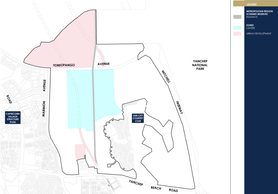
The Yanchep District Centre Structure Plan outlines the proposed development of the Yanchep District Centre, which is intended to be a major commercial and civic hub for the Yanchep area in Western Australia. The plan includes provisions for retail and commercial space, community facilities, and public transport connections. Its aim is to provide a central location for residents to access services and facilities, support economic development, and create a sense of place and community identity. The plan was developed through community engagement and consultation, and its implementation will continue to involve the community.

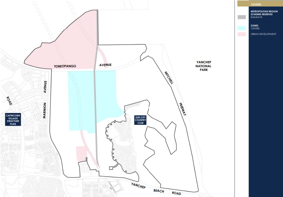
The Yanchep-Two Rocks Local Area Plan
The Yanchep-Two Rocks Local Area Plan is a planning document that outlines the long-term vision and planning framework for the Yanchep-Two Rocks area in Western Australia. The plan identifies the area's strengths and challenges and provides strategies and actions to guide future growth and development. The plan aims to create a sustainable and livable community, with a focus on promoting economic development, preserving natural assets, and providing access to services and amenities. It also emphasizes community engagement and consultation throughout the planning and implementation process. Overall, the Yanchep-Two Rocks Local Area Plan provides a comprehensive and integrated approach to managing growth and development in the area.

The Yanchep Rail Extension Project
The Yanchep Rail Extension Project is a major infrastructure project in Western Australia that involves extending the existing Joondalup Line to Yanchep in the north. The project includes the construction of 14.5 kilometers of new rail line, three new stations, and associated infrastructure, such as park and ride facilities and bike storage. The project aims to provide improved public transport options for residents in the growing northern corridor, reduce road congestion and travel times, and support economic development. The project is being delivered by the Western Australian government and is expected to be completed by 2023.
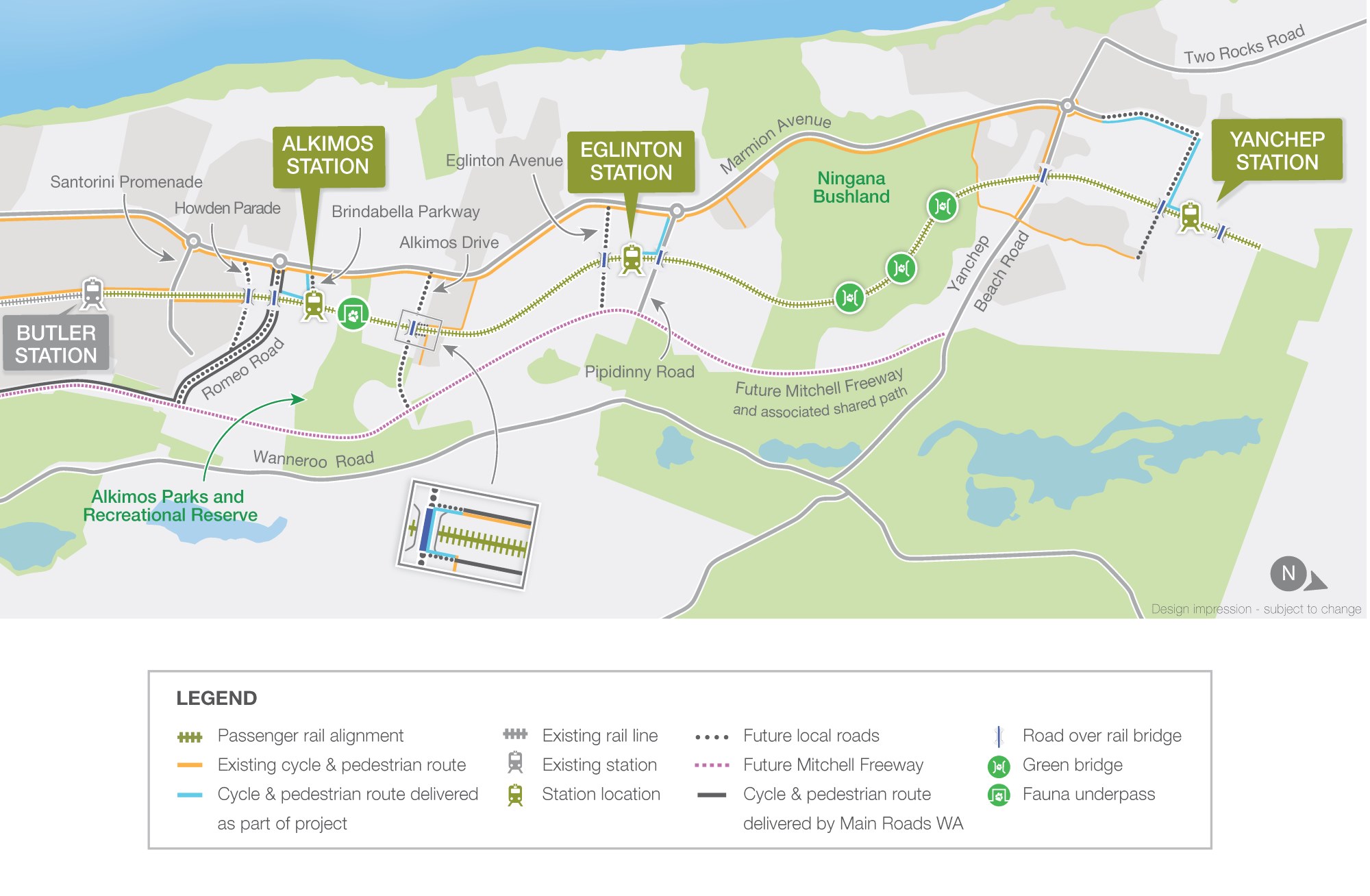
Wanneroo North-West District Structure Plan
The Wanneroo North-West District Structure Plan, which was approved by the Western Australian Planning Commission in 2004, established the framework for the development of the Wanneroo growth area, including the Yanchep area. This plan outlines the land use and development patterns, transportation, infrastructure, and environmental considerations for the area.
The Wanneroo North-West District Structure Plan aims to create a well-connected and sustainable community in Yanchep while preserving important natural features, public open space and conservation, including the Yanchep Regional Open Space and the Yanchep National Park. The open space is critical to providing for future density and growth.
This structure plan covers a large area, including Yanchep, and it outlines a framework for future development and land use within the district. Rezoning has occurred in several areas for different uses. Providing a new town centre that will include retail and commercial spaces as well as public amenities such as parks and community facilities. The plan also designates areas for residential development, including single-family homes, apartments, and townhouses.
The Western Australian Planning Commission released the vision for Wanneroo North-West District Structure Plan, as stated "The Wanneroo North-West District Structure Plan is a long-term vision that will guide the growth of the area over the next 30 years. It aims to create a sustainable, connected, and liveable community with a range of housing, employment, transport, and community facilities. The plan will provide for the conservation and protection of the area's natural environment, cultural heritage, and important landmarks while promoting economic growth and prosperity."

The Perth and Peel @ 3.5million
The frameworks aim to accommodate 3.5 million people by 2050 by creating vibrant communities within a compact and connected city; making best use of existing and proposed infrastructure; and protecting important environmental assets.
The framework encourages significantly greater infill development with almost half of the required 800,000 new homes – 380,000 at a minimum - to be built through infill development. The majority of these – around 214,000 – will be built in existing suburbs within the Central sub-region and particularly through alignment with the new METRONET rail project.
Western Australian Planning Commission produced the Wanneroo North-West District Structure Plan as part of the plan to facilitate the changes.
Directions 2031
This is an overarching strategic plan for the Perth metropolitan area published by the Western Australian Planning Commission. It replaced the draft 2004 Network City and was the first strategic plan to be formally adopted since Metroplan in 1991. Detailed sub-regional planning frameworks were published separately as part of Perth and Peel @ 3.5 million. These frameworks, covering Perth’s Central, North-West, North-East and Southern regions, included specific population targets for each area to accommodate 800,000 people by 2030
Suburb Summary
References
- Yanchep – SA State Government
- Yanchep - LDPs & R-Code Plans outside of an ASP area
- Yanchep City ASP No. 68
- Yanchep City Centre Activity Centre Structure Plan No. 100
- Yanchep South ASP No. 19
- Yanchep-Two Rocks District Structure Plan No. 43
- South Yanchep ASP No. 66
- Yanchep – Perth and Peel @ 3.5 million - WA Planning Submission
- Direction 2031
- Google Streetview and Aeria
Reviews & Comments on Jindowie Estate - Yanchep
Estate Brochure, Masterplan, Engineering Plan, Plan of Subdivision (POS), Design Guidelines
FAQs about Jindowie Estate - Yanchep
View all estates from DevelopmentWA
- Yanchep Secondary College - 629m south-west
- Yanchep Lagoon Primary School - 1.2km west
- Yanchep Rise Primary School - 1.2km north
- Yanchep Beach Primary School - 1.7km north-west
- Eglinton South West Primary School - 5.4km south
- Shorehaven Primary School - 6.4km south
Popular Estates near Jindowie Estate - Yanchep
Latest New Home Articles for You

13/Dec/2024
The Aussie Dream Is Alive: Despite Worry That New Homebuyers Must Settle for Apartments, New Data Reveals Australians Buy Twice as Many New Houses as Units
MELBOURNE (15 October 2024) — The Australian Dream of owning a detached h...

10/Dec/2024
Data Reveals It Costs 57% More to Build a New House than Before Covid
MELBOURNE (10 September 2024) — Australians are spending as much as 57% m...

21/Nov/2024
Decoding Terms Found In Drawings & Plans
In the latest episode of "The Home Building Hub" podcast, hosts Colin Bis...

12/Nov/2024
Victoria: Top 30 Most Searched Housing Developments (October 2024)
We’re excited to present the top 30 most popular housing developments in ...

12/Nov/2024
Western Australia: Top 30 Most Searched Housing Developments (October 2024)
If you've ever envisioned calling Western Australia home, now is an excel...

12/Nov/2024
South Australia: Top 30 Most Searched Housing Developments (October 2024)
South Australia, celebrated for its breathtaking landscapes and vibrant c...

12/Nov/2024
New South Wales: Top 30 Most Searched Housing Developments (October 2024)
If you've considered making New South Wales your home, now is an ideal ti...

12/Nov/2024
Queensland: Top 30 Most Searched Housing Developments (October 2024)
Spanning the sunlit shores of Australia’s eastern coast, Queensland—affec...
![[Oct/2024] Top Most Searched Housing Developments in Australia](https://files.openlot.com.au/p/styles/500h/s3/article/Thumbnail%20-%20Top%2030%20Most%20Searched%20Housing%20Developments_0.png.webp?itok=YtDmCKiT)
06/Nov/2024
[Oct/2024] Top Most Searched Housing Developments in Australia
OpenLot offers an in-depth look at top housing developments making an imp...


 Avon Road, Yanchep WA 6035

 4
4  2.5
2.5  2
2


