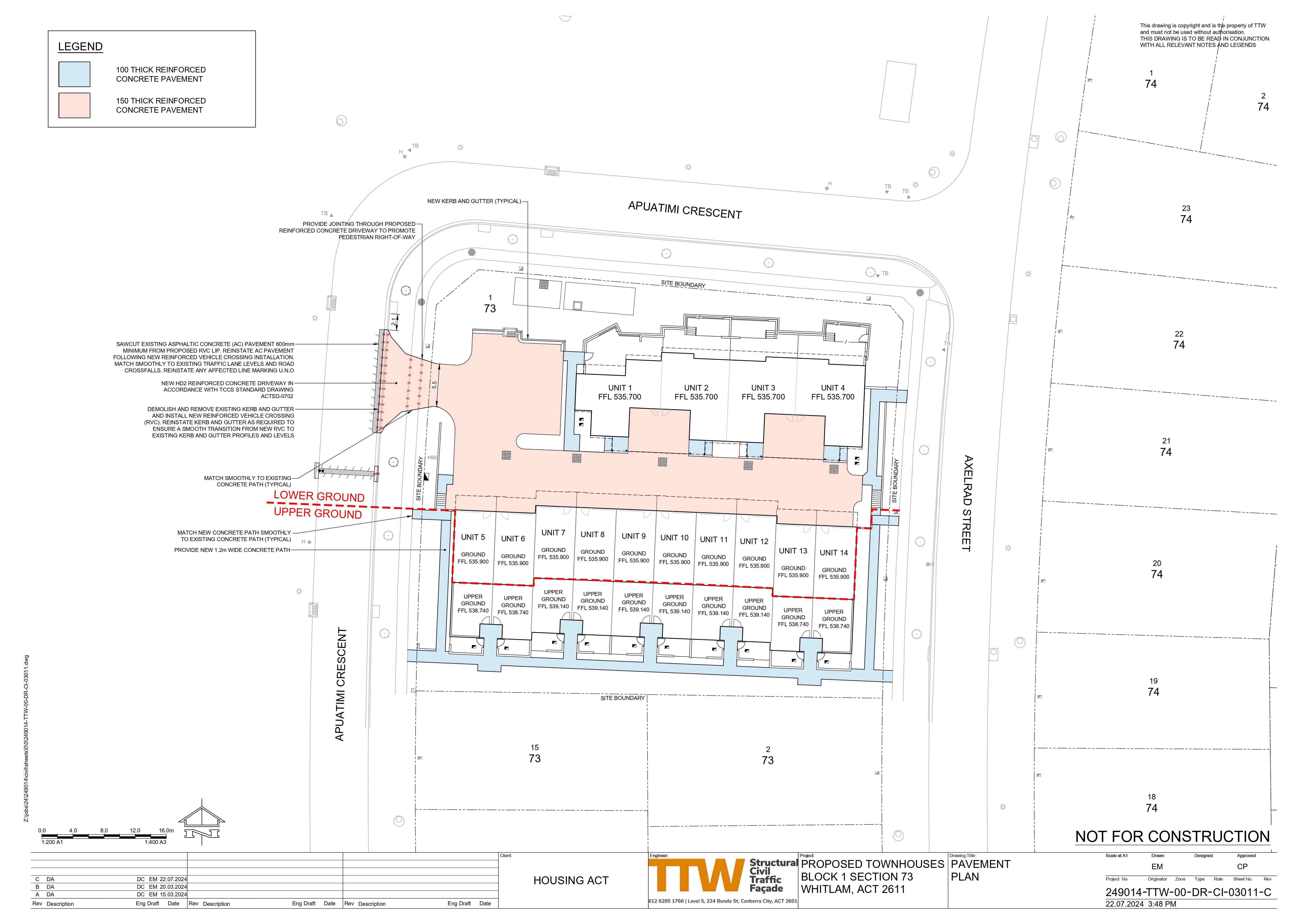

Axelrad Street, Whitlam ACT 2611 COMING SOON
This information is estimated by the OpenLot research team. Let us know here to provide up-to-date information about this development.
| Total new homes | 14 |
| Area size | 0.31 hectares |
| Growth Region | Canberra Growth Regions |
| City council | Australian Capital Territory |
| Developer | N/A |
| Distance to | Canberra CBD - 9 km west Canberra Airport - 15 km west |
Townhomes:
Popular Estates near Axelrad Street, Whitlam


 3
3  4
4  2
2


Updates for Axelrad Street, Whitlam

Location & Map for Axelrad Street, Whitlam
Visit Display Homes near Axelrad Street, Whitlam

Vacancy Rate in Whitlam ACT 2611
View full vacancy rate history in Whitlam ACT 2611 via SQM Research.
Schools near Axelrad Street, Whitlam
Here are 6 schools near Axelrad Street, Whitlam:
K-10 Government Combined School
K-6 Government Primary School
K-6 Government Primary School
7-10 Government Secondary School
11-12 Government Secondary School
K-6 Government Primary School
Reviews & Comments on Axelrad Street, Whitlam
Estate Brochure, Masterplan, Engineering Plan, Plan of Subdivision (POS), Design Guidelines
FAQs about Axelrad Street, Whitlam
- Evelyn Scott School - 3.0km south
- Hawker Primary School - 3.3km north
- Weetangera Primary School - 3.4km north-east
- Belconnen High School - 3.7km north
- Hawker College - 3.8km north
- Macquarie Primary School - 4.1km north-east
Popular Estates near Axelrad Street, Whitlam
Latest New Home Articles for You

11/Mar/2025 | OpenLot.com.au
4 Steps to Getting the Best Building Quotes
In the latest episode of the Home Building Hub podcast, hosts Colin Bisch...
10/Mar/2025 | OpenLot.com.au
Display Homes at Atherstone Estate: A Thriving Community in Melbourne’s Booming West
Welcome to Atherstone, a vibrant and flourishing masterplanned community ...

07/Mar/2025 | OpenLot.com.au
Kaduna Park: A New Chapter in Officer South's Real Estate Story
Nestled in the scenic beauty of Officer South, Kaduna Park is a testament...
![[Feb/2025] Top Most Searched Housing Developments in Australia](https://files.openlot.com.au/p/styles/500h/s3/article/Thumbnail%20-%20Top%2030%20Most%20Searched%20Housing%20Developments%20%281%29.png.webp?itok=wtjvzwHK)
06/Mar/2025 | OpenLot.com.au
[Feb/2025] Top Most Searched Housing Developments in Australia
OpenLot provides a comprehensive overview of leading housing developments...

05/Mar/2025 | OpenLot.com.au
Display Homes at Alfredton Grove Estate: A Premier Community in Alfredton's Growing West
Alfredton Grove has become one of the most desirable residential communit...

04/Mar/2025 | OpenLot.com.au
Display Homes at Ooranya: Beveredige's Perfect Blend of Country Living and Modern Convenience
Nestled in the charming town of Beveridge, Ooranya is a community designe...

03/Mar/2025 | OpenLot.com.au
The Rise of Regional Living: Why More Australians are Moving Beyond Major Cities
In recent years, Australia has witnessed a significant shift in populatio...

28/Feb/2025 | OpenLot.com.au
2025 Property Investment Strategies: How to Maximise ROI
As Australia’s real estate market evolves, property investors are seeking...

27/Feb/2025 | OpenLot.com.au
Display Homes at Everley: The Heart of Sunbury’s Newest Community
Everley proudly stands at the centre of Sunbury, offering an unparalleled...