
62-108 Talinga Drive, Park Ridge QLD 4125 IN PLANNING
This information is estimated by the OpenLot research team. Let us know here to provide up-to-date information about this development.
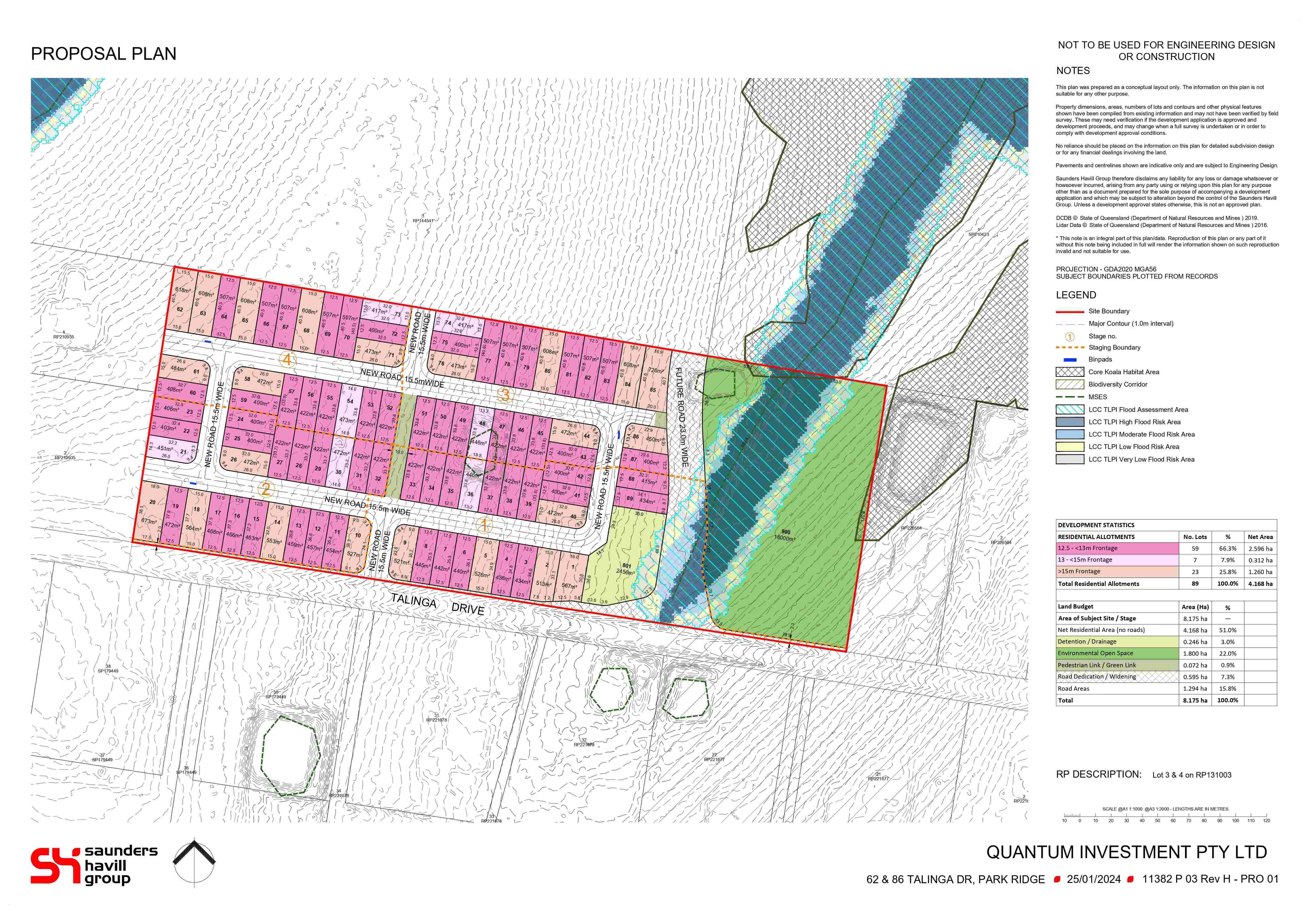
| Total new homes | 89 |
| Area size | 8.18 hectares |
| Growth Region | Greater Brisbane Growth Areas |
| City council | Logan City Council |
| Developer | N/A |
| Distance to | Brisbane CBD - 26 km south Brisbane Airport - 35 km south Gold Coast CBD - 48 km north-west |
Land for Sale, House and Land Packages:
Popular Estates near 62-108 Talinga Drive, Park Ridge


Updates for 62-108 Talinga Drive, Park Ridge
Facebook updates:
Submit the Facebook page for 62-108 Talinga Drive, Park Ridge.
Related news:

Missing articles? Send us a link here.
Location & Map for 62-108 Talinga Drive, Park Ridge
Visit Display Homes near 62-108 Talinga Drive, Park Ridge


Vacancy Rate in Park Ridge QLD 4125
View full vacancy rate history in Park Ridge QLD 4125 via SQM Research.
Schools near 62-108 Talinga Drive, Park Ridge
Here are 6 schools near 62-108 Talinga Drive, Park Ridge:
Prep-6 Government Primary School
Prep-12 Independent Combined School
7-12 Government Secondary School
Prep-6 Government Primary School
Prep-6 Government Primary School
Prep-6 Government Primary School
Reviews & Comments on 62-108 Talinga Drive, Park Ridge
Estate Brochure, Masterplan, Engineering Plan, Plan of Subdivision (POS), Design Guidelines
FAQs about 62-108 Talinga Drive, Park Ridge
- Park Ridge State School - 968m north-west
- Parklands Christian College - 1.4km south-west
- Park Ridge State High School - 1.5km north-west
- Regents Park State School - 3.0km north-west
- Yugumbir State School - 3.4km north
- Boronia Heights State School - 3.8km north-west
Popular Estates near 62-108 Talinga Drive, Park Ridge
Latest New Home Articles for You

06/Feb/2025
How to Finance Your First House and Land Package
Purchasing your first house and land package is an exciting milestone, of...

04/Feb/2025
Western Australia: Top 30 Most Searched Housing Developments (January 2025)
If you’ve ever considered making Western Australia your home, now is an i...

04/Feb/2025
South Australia: Top 30 Most Searched Housing Developments (January 2025)
South Australia, renowned for its stunning natural beauty and rich cultur...

04/Feb/2025
Queensland: Top 30 Most Searched Housing Developments (January 2025)
Stretching along Australia’s sun-drenched eastern coastline, Queensland—f...

04/Feb/2025
New South Wales: Top 30 Most Searched Housing Developments (January 2025)
If you're considering making New South Wales your home, now is a great ti...

04/Feb/2025
Victoria: Top 30 Most Searched Housing Developments (January 2025)
We’re excited to unveil the top 30 most popular housing developments in V...
![[Jan/2025] Top Most Searched Housing Developments in Australia](https://files.openlot.com.au/p/styles/500h/s3/article/Thumbnail%20-%20Australia%20Top%20Most%20Searched%20Housing%20Developments%20%285%29.png.webp?itok=pbPykfMh)
04/Feb/2025
[Jan/2025] Top Most Searched Housing Developments in Australia
OpenLot provides a comprehensive overview of leading housing developments...

20/Jan/2025
How to Choose the Perfect Floor Plan for Your Family
Choosing the perfect floor plan is one of the most important decisions yo...

14/Jan/2025
New South Wales: Top 30 Most Searched Housing Developments (December 2024)
If you’re thinking about making New South Wales your home, December is an...