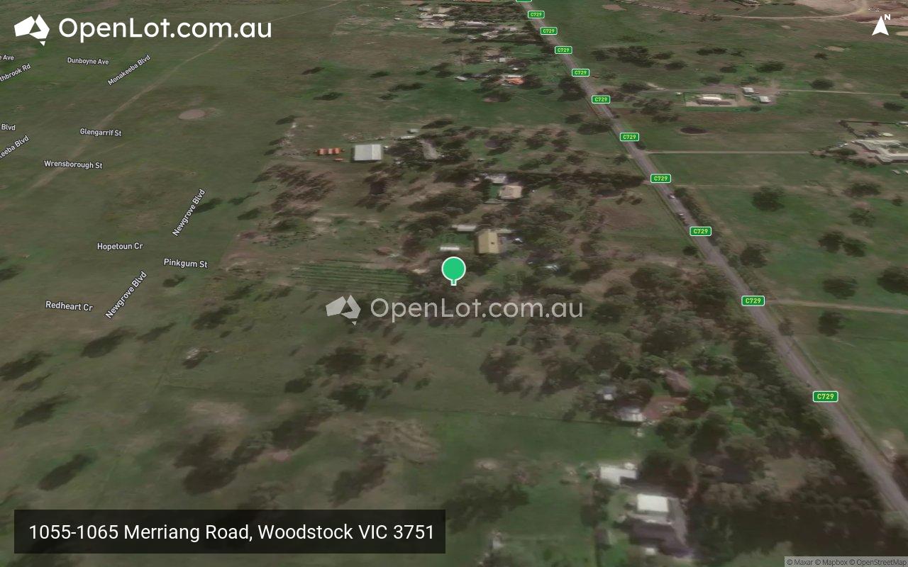
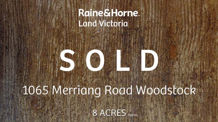
1055-1065 Merriang Road, Woodstock VIC 3751 IN PLANNING
This information is estimated by the OpenLot research team. Let us know here to provide up-to-date information about this development.
| Total new homes | N/A |
| Area size | 6.80 hectares |
| Growth Region | Melbourne North Growth Corridor |
| City council | Whittlesea City Council |
| Developer | LCH Group (Low Cost Housing Group) |
| Distance to | Melbourne Airport - 22 km north-east Melbourne CBD - 31 km north |
Land for Sale, House and Land Packages:
Popular Estates near 1055-1065 Merriang Road, Woodstock


 4
4  2
2  2
2


Updates for 1055-1065 Merriang Road, Woodstock
Facebook updates:
Submit the Facebook page for 1055-1065 Merriang Road, Woodstock.
Related news:
Missing articles? Send us a link here.
Location & Map for 1055-1065 Merriang Road, Woodstock
Display Homes near 1055-1065 Merriang Road, Woodstock


Vacancy Rate in Woodstock VIC 3751
View full vacancy rate history in Woodstock VIC 3751 via SQM Research.
Schools near 1055-1065 Merriang Road, Woodstock
Here are 6 schools near 1055-1065 Merriang Road, Woodstock:
Prep-6 Government Primary School
Prep-6 Government Primary School
Prep-6 Government Primary School
Prep-6 Government Primary School
7 Government Secondary School
Prep-6 Government Primary School
Suburb Planning Review in Woodstock VIC 3751
Woodstock is located in the city of Whittlesea, a semi-rural location to the north of Melbourne’s outer suburbs of the Urban Growth Boundary and logical expansion of the former Woodstock township. Woodstock growth area is 760ha and forms part of the new 1,786ha suburb area (Woodstock and Donnybrook) that is located on either side of Cameron Street. The new suburb is bounded by a possible future high-speed rail investigation area and Outer Metropolitan Ring Reservation (OMR / E6) for future road and rail transport links.

The Donnybrook-Woodstock Precinct Structure Plan (PSP) was prepared to guide the redevelopment of the released land for a mix of residential neighbourhoods linked by a variety of local town centres, schools and other community facilities. Protection of natural assets along the Merri Creek and Darebin Creek linear conservation corridors are provided to protect the Growling Grass Frog habitat from the planned suburb.

The Donnybrook-Woodstock PSP was prepared by Victorian Planning Authority (VPA) in consultation with the Whittlesea City Council and was approved by the Minister for Planning in November 2017. The decision was officially gazetted on 3 November 2017 under Amendment GC28 of the Whittlesea Planning Scheme.
The Vision
“Development will have a strong emphasis on the retention of natural features and high quality landscaping in an urban environment supported by strong connections to transport and community facilities. Development of the precinct will create a diverse mix of residential neighbourhoods linked by a variety of local town centres, schools and other community facilities.
The distribution of local centres which serve a variety of roles and functions will promote self-sufficiency for residents of the precinct in meeting daily retail and convenience shopping needs. Residential and business development will capitalise on the precinct’s proximity to the existing Donnybrook train station, as well as the future Lockerbie Principal Town Centre and potential future Lockerbie Train Station. The development of the existing Donnybrook Cheese Farm into an agricultural, historical and cultural learning hub will provide new residents with connections to the history of the area”.

Benefits
The existing zoning will be amended to provide for Rural Conservation and Urban Growth Zones, providing a series of greenfield sites in proximity to natural corridors. The amendments provide a new residential community, protection of natural features, parks, and sports and recreation areas. The Structure Plan also supports new schools, local community hubs, local centres to provide employment and services to the new suburb.
Transportation
Woodstock is well connected to public passenger transport, with the Donnybrook train station located to the east outside the new suburb boundary and a future north train station to be built in Lockerbie. The passenger train service connects Melbourne to Sydney and is being considered for a high speed rail project.
The suburb will include a network of shared paths linking the local parks and a new road network. Donnybrook Road and a new future state arterial road will provide access to the Hume Freeway, providing a direct connection to Melbourne CBD or northern Victoria.
Suburb Summary
References
Planning Applications for 1055-1065 Merriang Road, Woodstock
| Planning Application | Land report | Number of lots | Plan number | Land surveyor | Lodged date | Intended use | Settlement tracking | |||||||||||||||||||||||||||||||||||||||||||||||||||||||||||||||||||||||||||||||||||||||||||
|---|---|---|---|---|---|---|---|---|---|---|---|---|---|---|---|---|---|---|---|---|---|---|---|---|---|---|---|---|---|---|---|---|---|---|---|---|---|---|---|---|---|---|---|---|---|---|---|---|---|---|---|---|---|---|---|---|---|---|---|---|---|---|---|---|---|---|---|---|---|---|---|---|---|---|---|---|---|---|---|---|---|---|---|---|---|---|---|---|---|---|---|---|---|---|---|---|---|---|
| No updates found |
Reviews & Comments on 1055-1065 Merriang Road, Woodstock
Estate Brochure, Masterplan, Engineering Plan, Plan of Subdivision (POS), Design Guidelines
FAQs about 1055-1065 Merriang Road, Woodstock
View all estates from LCH Group (Low Cost Housing Group)
- Donnybrook Primary School - 2.8km west
- Gilgai Plains Primary School - 6.2km west
- Barrawang Primary School - 6.8km south-west
- Wollert Primary School - 7.6km south
- Wollert Secondary College - 7.6km south
- Edgars Creek Primary School - 7.6km south
Popular Estates near 1055-1065 Merriang Road, Woodstock
Latest New Home Articles for You

13/Dec/2024
The Aussie Dream Is Alive: Despite Worry That New Homebuyers Must Settle for Apartments, New Data Reveals Australians Buy Twice as Many New Houses as Units
MELBOURNE (15 October 2024) — The Australian Dream of owning a detached h...

10/Dec/2024
Data Reveals It Costs 57% More to Build a New House than Before Covid
MELBOURNE (10 September 2024) — Australians are spending as much as 57% m...

21/Nov/2024
Decoding Terms Found In Drawings & Plans
In the latest episode of "The Home Building Hub" podcast, hosts Colin Bis...

12/Nov/2024
Victoria: Top 30 Most Searched Housing Developments (October 2024)
We’re excited to present the top 30 most popular housing developments in ...

12/Nov/2024
Western Australia: Top 30 Most Searched Housing Developments (October 2024)
If you've ever envisioned calling Western Australia home, now is an excel...

12/Nov/2024
South Australia: Top 30 Most Searched Housing Developments (October 2024)
South Australia, celebrated for its breathtaking landscapes and vibrant c...

12/Nov/2024
New South Wales: Top 30 Most Searched Housing Developments (October 2024)
If you've considered making New South Wales your home, now is an ideal ti...

12/Nov/2024
Queensland: Top 30 Most Searched Housing Developments (October 2024)
Spanning the sunlit shores of Australia’s eastern coast, Queensland—affec...
![[Oct/2024] Top Most Searched Housing Developments in Australia](https://files.openlot.com.au/p/styles/500h/s3/article/Thumbnail%20-%20Top%2030%20Most%20Searched%20Housing%20Developments_0.png.webp?itok=YtDmCKiT)
06/Nov/2024
[Oct/2024] Top Most Searched Housing Developments in Australia
OpenLot offers an in-depth look at top housing developments making an imp...