
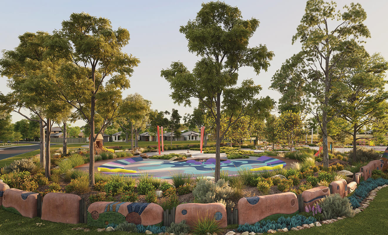
Platform Estate - Donnybrook SOLD OUT
 805 Donnybrook Road, Donnybrook VIC 3064
- 3 minutes walk to Donnybrook Station
- 2/3/4 bedroom townhouses available from $385,000
This information is estimated by the OpenLot research team. Let us know here to provide up-to-date information about this development.
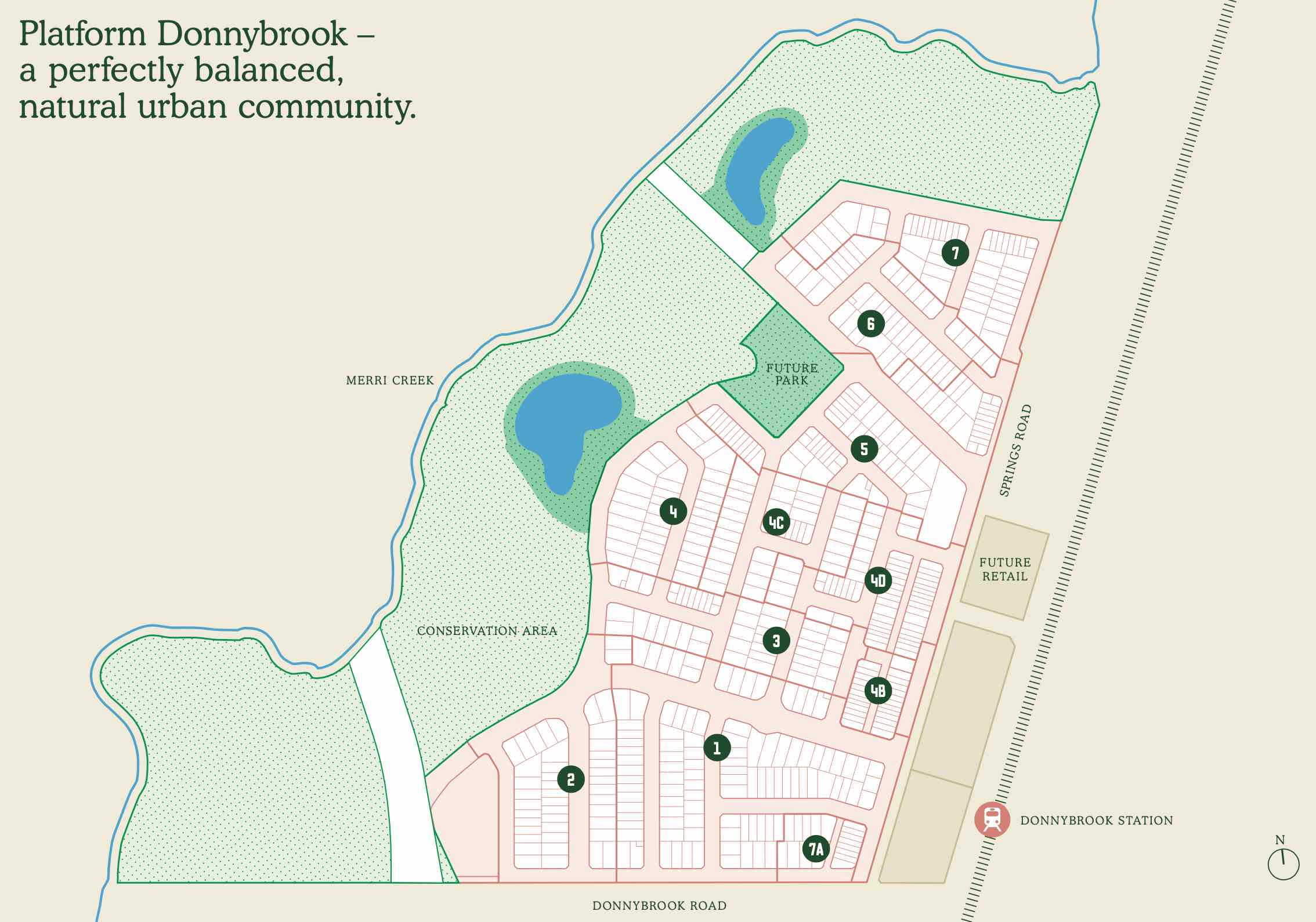
| Total new homes | 581 |
| Area size | 52.00 hectares |
| Growth Region | Melbourne North Growth Corridor |
| City council | Whittlesea City Council |
| Developer | Wolfdene, Blueways Group |
| Distance to | Melbourne Airport - 18 km north-east Melbourne CBD - 31 km north |
Land for Sale, House and Land Packages, Townhomes:
Popular Estates near Platform Estate - Donnybrook

Stockland Cloverton - Kalkallo

Stockland Lyra Estate - Beveridge

Mandalay Estate - Beveridge

Merrifield - Mickleham

Peppercorn Hill Estate - Donnybrook

Kinbrook - Donnybrook

Mason Quarter Estate - Wollert

Stockland Katalia - Donnybrook

Stockland Highlands - Mickleham
Updates for Platform Estate - Donnybrook
Facebook updates:
Related news:
Wolfdene is a multi-disciplined property firm with in-house design, project management, marketing and real estate sales capabilities.
Land developer Wolfdene has tackled the growing affordability crisis in the Melbourne house-and-land market by cutting lot sizes in half.

Missing articles? Send us a link here.
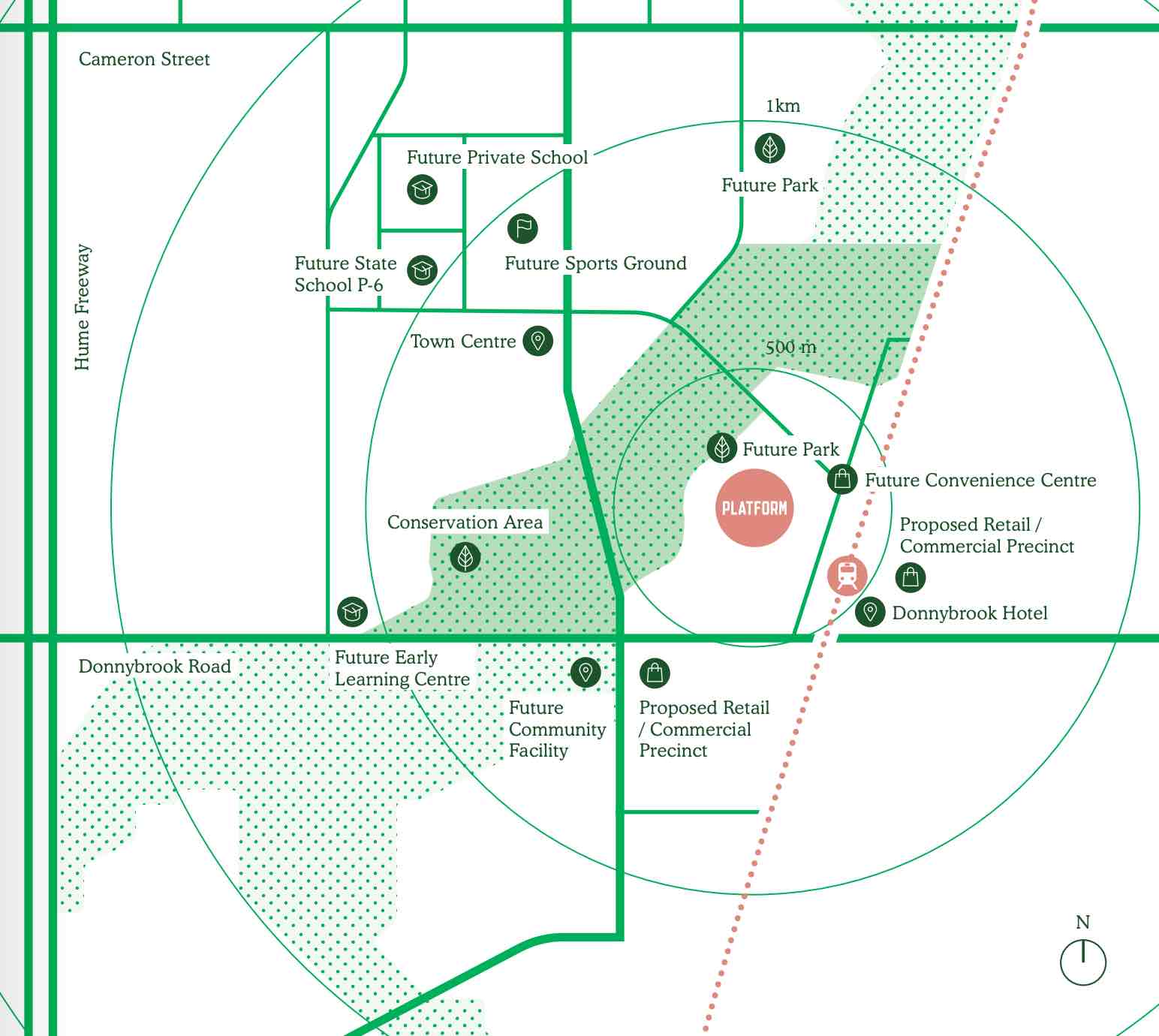
Location & Map for Platform Estate - Donnybrook
Land Price Trend in Donnybrook VIC 3064
- In Jul - Sep 23, the median price for vacant land in Donnybrook VIC 3064 was $286,000. *
- From Oct - Dec 17 to Jul - Sep 23, the median price for vacant land in Donnybrook VIC 3064 has increased 50.53%. *
- From 2014 to 2022, the median price for vacant land in Donnybrook VIC 3064 has increased 59.34%. *
Vacancy Rate in Donnybrook VIC 3064
View full vacancy rate history in Donnybrook VIC 3064 via SQM Research.
Schools near Platform Estate - Donnybrook
Here are 6 schools near Platform Estate - Donnybrook:
Prep-6 Government Primary School
Prep-12 Independent Combined School - School Head Campus
Prep-6 Catholic Primary School
Prep-6 Government Primary School
Prep-6 Catholic Primary School
Prep-6 Government Primary School
Suburb Planning Review in Donnybrook VIC 3064
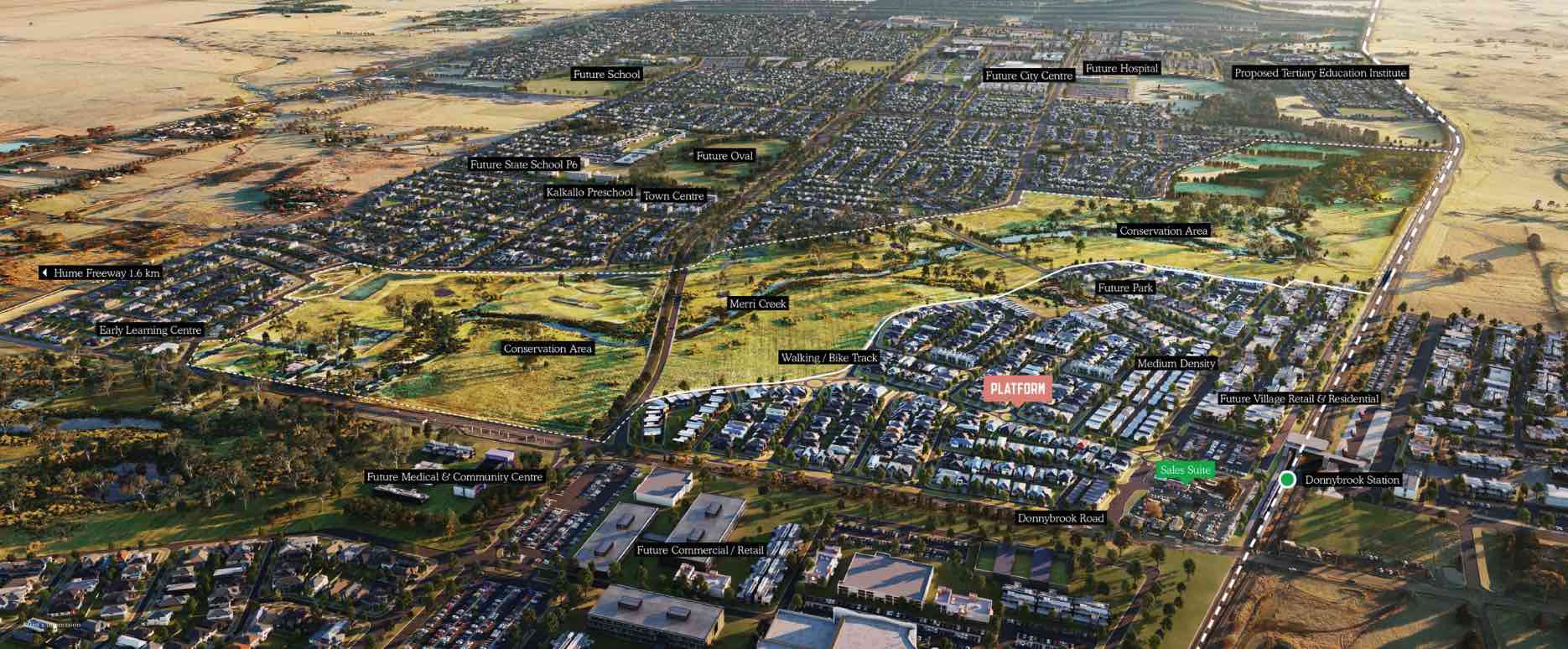
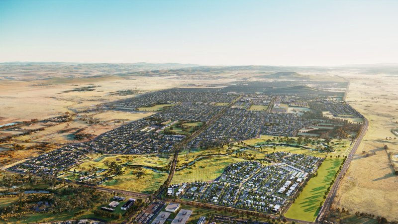
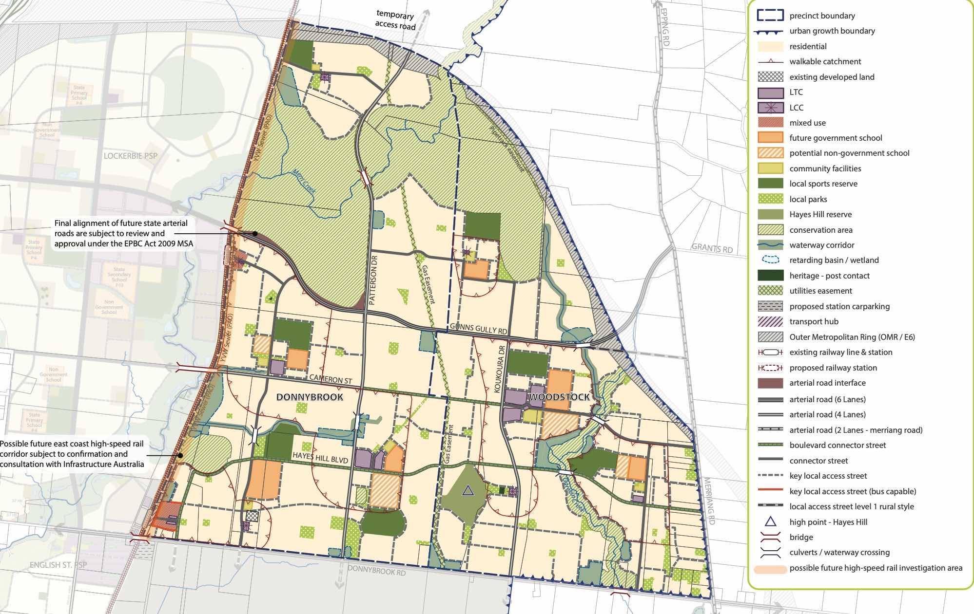
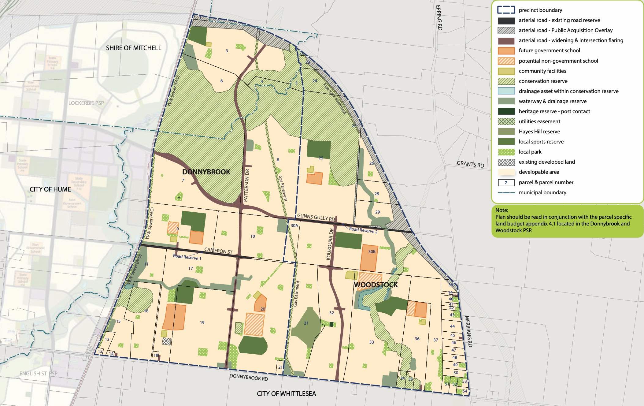
Donnybrook is located in the Shire of Mitchell, a semi-rural location to the north of Melbourne’s outer suburbs of the Urban Growth Boundary and logical expansion of the former Donnybrook township. Donnybrook growth area is 1,026ha and forms part of the new 1,786ha suburb area (Woodstock and Donnybrook) that is located on either side of Cameron Street.
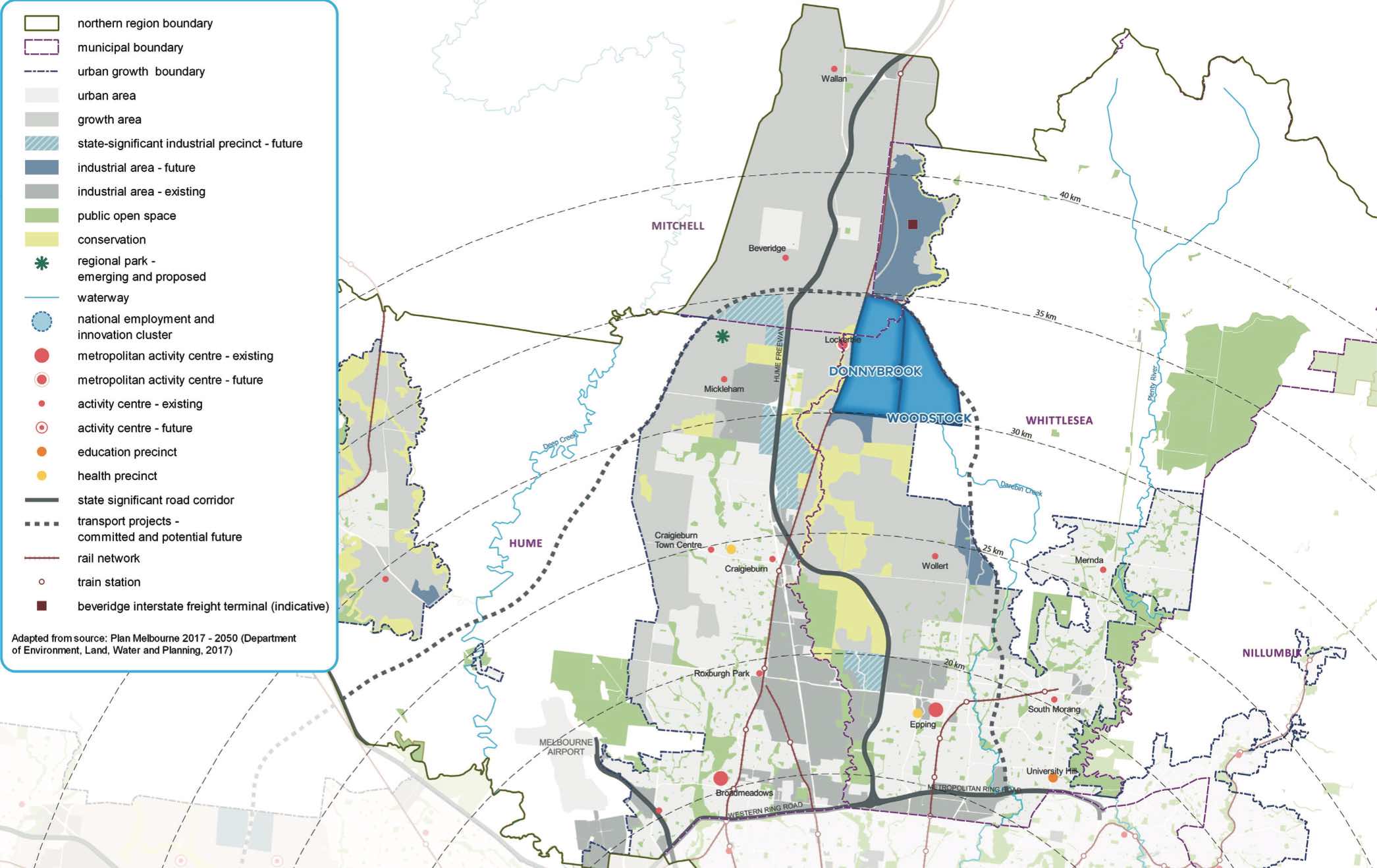
The new suburb is bounded by a possible future high-speed rail investigation area and Outer Metropolitan Ring Reservation (OMR / E6) for future road and rail transport links.
The Donnybrook-Woodstock Precinct Structure Plan (PSP) was prepared to guide the redevelopment of the released land for a mix of residential neighbourhoods linked by a variety of local town centres, schools and other community facilities. Protection of natural assets along the creek corridor and conservation area are provided to protect the Growling Grass Frog habitat from the planned suburb.
The Donnybrook-Woodstock PSP was prepared by Victorian Planning Authority (VPA) in consultation with the Whittlesea City Council and was approved by the Minister for Planning in November 2017. The decision was officially gazetted on 3 November 2017 under Amendment GC28 of the Whittlesea Planning Scheme.
The Vision
“Development will have a strong emphasis on the retention of natural features and high quality landscaping in an urban environment supported by strong connections to transport and community facilities. Development of the precinct will create a diverse mix of residential neighbourhoods linked by a variety of local town centres, schools and other community facilities.
The distribution of local centres which serve a variety of roles and functions will promote self-sufficiency for residents of the precinct in meeting daily retail and convenience shopping needs. Residential and business development will capitalise on the precinct’s proximity to the existing Donnybrook train station, as well as the future Lockerbie Principal Town Centre and potential future Lockerbie Train Station. The development of the existing Donnybrook Cheese Farm into an agricultural, historical and cultural learning hub will provide new residents with connections to the history of the area”.
Benefits
The Structure Plan also supports new schools, local community hubs, local centres to provide employment and services to the new suburb. The amendments provide a new residential community, protection of natural features, parks, and sports and recreation areas. The existing zoning will be amended to provide for Rural Conservation and Urban Growth Zones, providing a series of greenfield sites in proximity to natural water corridors and reserves.
Transportation
Donnybrook is well connected to public passenger transport, with a future train station to be in Lockerbie and an existing train station located in Donnybrook train station outside the new suburb boundary. The passenger train service connects Melbourne to Sydney and is being considered for a high speed rail project.
The suburb will include a network of shared paths linking the local parks and a new road network. Donnybrook Road and a new future state arterial road will provide access to the Hume Freeway, providing a direct connection to Melbourne CBD or northern Victoria.
Summary
References
City of Whittlesea - Donnybrook
Victoria Planning Authority – Planning Schemes
Victoria Planning Authority – Donnybrook – Woodstock PSP
Planning Applications for Platform Estate - Donnybrook
| Planning Application | Land report | Number of lots | Plan number | Land surveyor | Lodged date | Intended use | Settlement tracking |
|---|---|---|---|---|---|---|---|
| Platform Stage 7A | 19a Railway Avenue, Donnybrook VIC 3064 | 17 | PS846191W, 37042/Stg7A, 717219, 610517 | Marshal Melbourne Pty Ltd | 15/02/2021 | Registered at Land Use Victoria | |
| Platform Stage 9 | 805j Donnybrook Road, Donnybrook VIC 3064 | 11 | PS846190Y, 37042/Stg9, 717219, 610500 | Marshal Melbourne Pty Ltd | 25/01/2021 | Registered at Land Use Victoria | |
| Platform | 55 Springs Road, Donnybrook VIC 3064 | 0 | AV306274C, 37042/COE4, 717219, 610395 | Marshal Melbourne Pty Ltd | 04/09/2020 | Registered at Land Use Victoria | |
| Platform Stage 5A | 35 Springs Road, Donnybrook VIC 3064 55 Springs Road, Donnybrook VIC 3064 805h Donnybrook Road, Donnybrook VIC 3064 | 47 | PS832758W, 37042/Stg5A, 717219, 610372 | Marshal Melbourne Pty Ltd | 31/07/2020 | Registered at Land Use Victoria | |
| Platform | 53 Springs Road, Donnybrook VIC 3064 | 0 | AV272807B, 37042/COE3, 717219, 610393 | Marshal Melbourne Pty Ltd | 04/09/2020 | Registered at Land Use Victoria | |
| Platform Stage 4G | 1 Nature Promenade, Donnybrook VIC 3064 100u Toyon Road, Donnybrook VIC 3064 | 1 | PS832755D, 37042/Stg4G, 717219, 610331 | Marshal Melbourne Pty Ltd | 29/05/2020 | Registered at Land Use Victoria | |
| Platform Stage 4F | 53 Springs Road, Donnybrook VIC 3064 | 1 | PS832751M, 37042/Stg4F, 717219 PPARS, 610330 | Watsons | 29/05/2020 | Referral | |
| Platform Stage 4E | 1 Springs Road, Donnybrook VIC 3064 | 2 | PS832750P, 37042/Stg4E, 717219, 610328 | Marshal Melbourne Pty Ltd | 29/05/2020 | Registered at Land Use Victoria | |
| Platform Stage 7 | Toyon Road, Donnybrook VIC 3064 | 36 | PS832727J, 37042/Stg7, 717219, 610280 | Marshal Melbourne Pty Ltd | 31/03/2020 | Registered at Land Use Victoria | |
| Platform Estate ROE1 | 35 Springs Road, Donnybrook VIC 3064 55 Springs Road, Donnybrook VIC 3064 | 0 | 37042_ROE1, 37042/ROE1, 610317, 610317, 719389 PPARS | Watsons | 11/05/2020 | This application is to remove the Easement E-1 for the purpose of Carriageway created in PS 813131C, as part of the registration of PS 821920C; and to remove the Easement E-1 for the purpose of Carriageway created in Transfer 668502, as part of the registration of PS 832727J. PS 821920C is the proposed Plan of Subdivision for Stage 5 of Platform Estate and PS 832727J is the proposed Plan of Subdivision for Stage 7, as shown on endorsed subdivision layout plan under Planning Permit 717219. It is our intention that road created in PS 821920C connects Lot B on PS 813131C to Springs Road, removing the need for the easement created in PS 813131C; and the road created in PS 832727J removes the need for the easement created in Transfer 832727J. A Proposed Plan of Removal of Easement (Watsons Plan Ref: 37042 ROE1) is attached in support of this application identifying the easement to be removed. | Final Referral Response (Permit) |
| Platform Stage 6 | Toyon Road, Donnybrook VIC 3064 | 34 | PS832726L, 37042/Stg6, 717219, 610268 | Marshal Melbourne Pty Ltd | 03/03/2020 | Registered at Land Use Victoria | |
| Platform Estate Stage 5 | Springs Road, Donnybrook VIC 3064 | 52 | PS821920C, 37042/Stg5, 717219, 610249 | Marshal Melbourne Pty Ltd | 12/02/2020 | Registered at Land Use Victoria | |
| Platform Stage 4D | Spi L\ps832724 | 51 | PS832725N, 37042/Stg4D, 610139, 610139, 717219 DA File | Marshal Melbourne Pty Ltd | 03/09/2019 | Registered at Land Use Victoria | |
| Platform Stage 4C | Springs Road, Donnybrook VIC 3064 | 38 | PS832724Q, 37042/Stg4C, 610120, 610120 | Marshal Melbourne Pty Ltd | 06/08/2019 | Registered at Land Use Victoria | |
| Platform Stage 4B | Springs Road, Donnybrook VIC 3064 | 24 | PS821933S, 37042/Stg4B, 717219, 610114 | Marshal Melbourne Pty Ltd | 30/07/2019 | Registered at Land Use Victoria | |
| Platform | 53 Springs Road, Donnybrook VIC 3064 | 0 | AT725248H, 37042/COE2, 610104, 610104, 718728 PPARS | Marshal Melbourne Pty Ltd | 17/07/2019 | For the Creation of Easements on Lot B PS813131 (Rural Conservation Land - Area 34) to cover services required for Platform Estate, including proposed Wetland (RBWL-10A). | Registered at Land Use Victoria |
| Platform Stage 4A | 53 Springs Road, Donnybrook VIC 3064 805b Donnybrook Road, Donnybrook VIC 3064 | 3 | PS821921A, 37042/Stg4A, 717219, 610093 | Marshal Melbourne Pty Ltd | 10/07/2019 | Registered at Land Use Victoria | |
| Platform Stage 3A | 1 Springs Road, Donnybrook VIC 3064 | 1 | PS821936L, 37042/stg3A, 717219, 610048 | Marshal Melbourne Pty Ltd | 21/05/2019 | Registered at Land Use Victoria | |
| Platform Stage 4 | 1 Springs Road, Donnybrook VIC 3064 Springs Road, Donnybrook VIC 3064 | 37 | PS821919L, 37042/Stg4, 610007, 610007, 717219 DA File | Marshal Melbourne Pty Ltd | 14/03/2019 | Registered at Land Use Victoria | |
| Platform | 35 Springs Road, Donnybrook VIC 3064 | 0 | AT728966J, 37042/COE1, 610002, 610002, 718368 PPARS | Marshal Melbourne Pty Ltd | 12/03/2019 | Creation of Easements to cover proposed assets as required for Platform Estate. | Registered at Land Use Victoria |
| Platform Stage 3 | 805 Donnybrook Road, Donnybrook VIC 3064 | 44 | PS821911D, 37042/stg3, 717219, 609911 | Marshal Melbourne Pty Ltd | 30/10/2018 | Registered at Land Use Victoria | |
| Platform stage 2 | 805 Donnybrook Road, Donnybrook VIC 3064 | 44 | PS821910F, 37042/stg2, 717219, 609910 | Watsons | 30/10/2018 | Registered at Land Use Victoria | |
| Platform Stage 1 | 805 Donnybrook Road, Donnybrook VIC 3064 | 102 | PS821909P, 37042/stg1, 717219, 609909, 717219 | Watsons | 30/10/2018 | Registered at Land Use Victoria |
Reviews & Comments on Platform Estate - Donnybrook
Estate Brochure, Masterplan, Engineering Plan, Plan of Subdivision (POS), Design Guidelines
FAQs about Platform Estate - Donnybrook
View all estates from Wolfdene
View all estates from Blueways Group
- Gilgai Plains Primary School - 1.1km north-west
- Hume Anglican Grammar - 4.5km south-west
- Mother Teresa School - 5.0km south-west
- Gaayip-Yagila Primary School - 5.3km west
- Holy Cross Catholic Primary School - 5.5km west
- Craigieburn Primary School - 5.6km south-west
Popular Estates near Platform Estate - Donnybrook
Stockland Cloverton - Kalkallo
Stockland Lyra Estate - Beveridge
Mandalay Estate - Beveridge
Merrifield - Mickleham
Peppercorn Hill Estate - Donnybrook
Kinbrook - Donnybrook
Mason Quarter Estate - Wollert
Stockland Katalia - Donnybrook
Stockland Highlands - Mickleham
Latest New Home Articles for You

17/May/2024
How to Approach Builders: The Do's and Don'ts for Homebuyers
In the latest episode of the Home Building Hub podcast, hosts Colin Bisch...

13/May/2024
Transformative Changes in Australia's Home Building Landscape with NCC 2022 Revisions
Australia's home building sector is undergoing a significant transformati...

10/May/2024
Insights into Conveyancing
In a recent episode, Colin Bischof and Darren Brennan discussed the intri...

08/May/2024
Market Update With OpenLot's Ryan Smits
In a recent episode of the Home Building Hub podcast, industry experts Co...
![[Apr/2024] Top Most Searched Housing Developments in Australia](https://files.openlot.com.au/p/styles/500h/s3/article/Thumbnail%20-%20Australia%20Top%20Most%20Searched%20Housing%20Developments.jpg.webp?itok=iKXIJbcX)
07/May/2024
[Apr/2024] Top Most Searched Housing Developments in Australia
In March 2024, OpenLot unveils a comprehensive showcase of the top-perfor...

06/May/2024
Essential Tips for Home Builders: Top 10 Considerations You Shouldn't Overlook
In the ever-evolving landscape of home construction, it's crucial to stay...

01/May/2024
New Homes vs. Secondhand: Why Building New Might Be Your Best Choice
In the latest episode of The Home Building Hub podcast, hosts Colin Bisch...

30/Apr/2024
The Power of Co Living Investing
In the latest episode of The Property Now Podcast, hosts Matt Ellul and B...

29/Apr/2024
Titled Land vs Non-titled Land - Which is better?
In the latest episode of the Home Building Hub podcast, hosts Colin Bisch...