
Arum Estate - Springfield
 89 Springfield Road, Springfield NSW 2250
This information is estimated by the OpenLot research team. Let us know here to provide up-to-date information about this development.
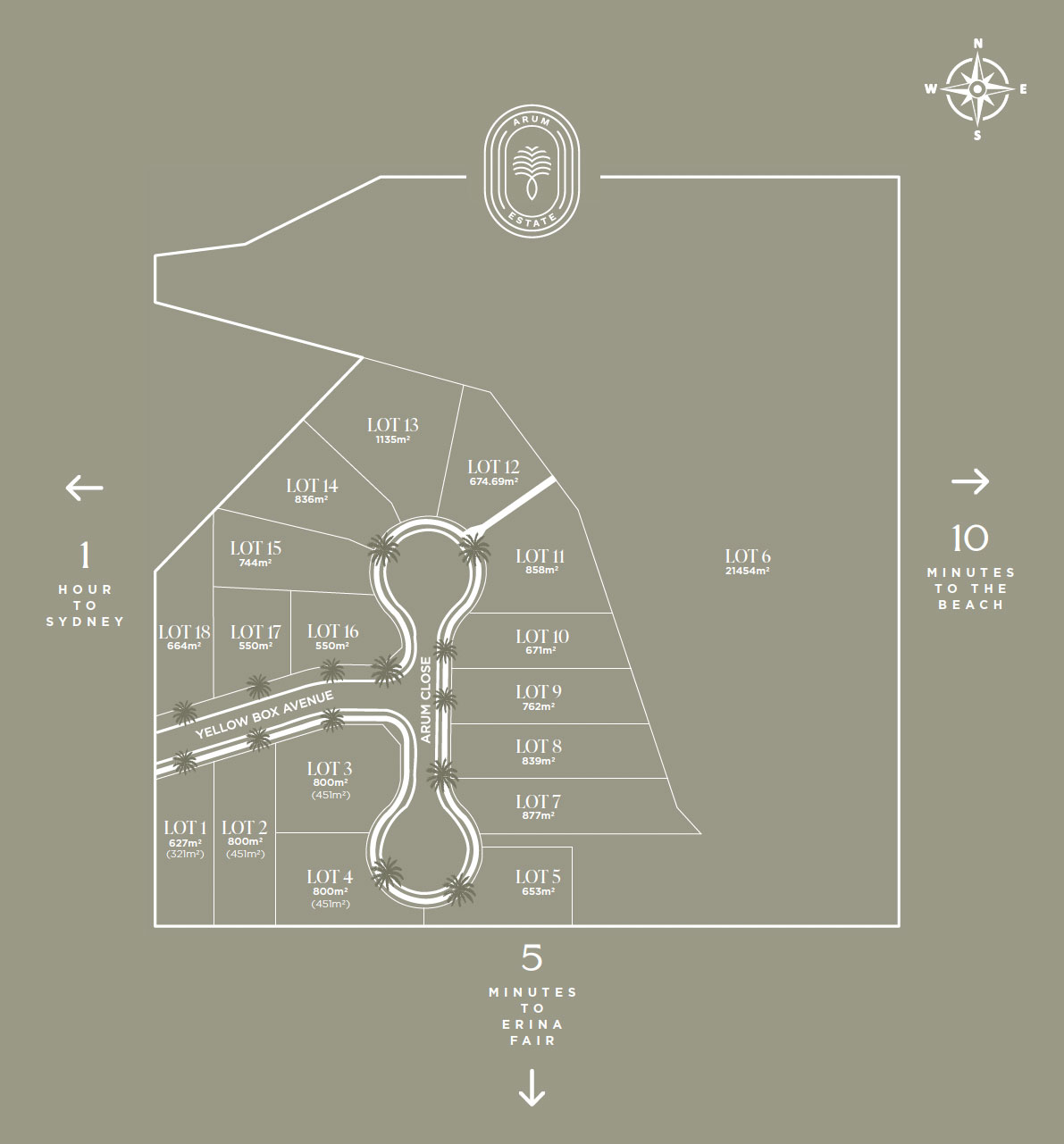
| Total new homes | 18 |
| Area size | 3.95 hectares |
| Growth Region | Central Coast Growth Areas |
| City council | Central Coast Council |
| Developer | N/A |
| Creative agency | Dream Town Projects |
| Distance to | Sydney CBD - 52 km north |
Land for Sale, House and Land Packages:
Popular Estates near Arum Estate - Springfield


Updates for Arum Estate - Springfield
Facebook updates:

Location & Map for Arum Estate - Springfield
Vacancy Rate in Springfield NSW 2250
View full vacancy rate history in Springfield NSW 2250 via SQM Research.
Schools near Arum Estate - Springfield
Here are 6 schools near Arum Estate - Springfield:
K-6 Government Primary School
U Government Special School
Unknown Government Special School
K-6 Government Primary School
K-6 Catholic Primary School
K-6 Catholic Primary School
Reviews & Comments on Arum Estate - Springfield
Estate Brochure, Masterplan, Engineering Plan, Plan of Subdivision (POS), Design Guidelines
FAQs about Arum Estate - Springfield
- Chertsey Primary School - 595m south
- North Gosford Learning Centre - 1.9km north-west
- Rumbalara Environmental Education Centre - 1.9km west
- Woodport Public School - 2.0km south-east
- St Patrick's Catholic Primary School - 2.1km south-west
- Our Lady of the Rosary Catholic Primary School - 2.1km north-west
Popular Estates near Arum Estate - Springfield
Latest New Home Articles for You

17/May/2024
How to Approach Builders: The Do's and Don'ts for Homebuyers
In the latest episode of the Home Building Hub podcast, hosts Colin Bisch...

13/May/2024
Transformative Changes in Australia's Home Building Landscape with NCC 2022 Revisions
Australia's home building sector is undergoing a significant transformati...

10/May/2024
Insights into Conveyancing
In a recent episode, Colin Bischof and Darren Brennan discussed the intri...

08/May/2024
Market Update With OpenLot's Ryan Smits
In a recent episode of the Home Building Hub podcast, industry experts Co...
![[Apr/2024] Top Most Searched Housing Developments in Australia](https://files.openlot.com.au/p/styles/500h/s3/article/Thumbnail%20-%20Australia%20Top%20Most%20Searched%20Housing%20Developments.jpg.webp?itok=iKXIJbcX)
07/May/2024
[Apr/2024] Top Most Searched Housing Developments in Australia
In March 2024, OpenLot unveils a comprehensive showcase of the top-perfor...

06/May/2024
Essential Tips for Home Builders: Top 10 Considerations You Shouldn't Overlook
In the ever-evolving landscape of home construction, it's crucial to stay...

01/May/2024
New Homes vs. Secondhand: Why Building New Might Be Your Best Choice
In the latest episode of The Home Building Hub podcast, hosts Colin Bisch...

30/Apr/2024
The Power of Co Living Investing
In the latest episode of The Property Now Podcast, hosts Matt Ellul and B...

29/Apr/2024
Titled Land vs Non-titled Land - Which is better?
In the latest episode of the Home Building Hub podcast, hosts Colin Bisch...